This article needs additional citations for verification. (March 2021) |
| Weser Werser (Low German) | |
|---|---|
 The Weser near Bad Oeynhausen | |
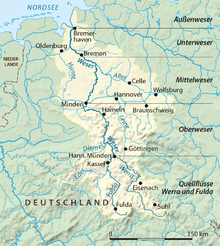
 Watershed of the Weser | |
| Etymology | *waisōn, Proto-Germanic, meaning "flow" or "ooze" |
| Location | |
| Country | Germany |
| States | |
| Cities | |
| Physical characteristics | |
| Source | |
| • location | Confluence of the Fulda and Werra Rivers in Hann. Münden |
| • coordinates | 51°25′17″N 9°38′53″E / 51.42139°N 9.64806°E |
| • elevation | 116 m (381 ft) |
| Mouth | Wadden Sea of the North Sea |
• location | Between Bremerhaven and Nordenham |
• coordinates | 53°32′8″N 8°33′56″E / 53.53556°N 8.56556°E |
• elevation | 0 m (0 ft) |
| Length | 452 km (281 mi) [744 km (462 mi) if combined with the Werra] |
| Basin size | 46,306 km2 (17,879 sq mi) |
| Discharge | |
| • average | 327 m3/s (11,500 cu ft/s) |
| Basin features | |
| River system | Weser basin |
| Tributaries | |
| • left | Diemel, Emmer, Werre, Große Aue, Hunte |
| • right | Aller, Lesum |
 | |

The Weser (pronounced [ˈveːzɐ] ) is a river of Lower Saxony in north-west Germany. It begins at Hannoversch Münden through the confluence of the Werra and Fulda. It passes through the Hanseatic city of Bremen. Its mouth is 50 km (31 mi) further north against the ports of Bremerhaven and Nordenham. The latter is on the Butjadingen Peninsula. It then merges into the North Sea via two highly saline, estuarine mouths.
It connects to the canal network running east–west across the North German Plain.
The river, when combined with the Werra (a dialectal form of Weser),[citation needed] is 744 km (462 mi) long and thus, the longest river entirely situated within Germany (the Main, however, is the longest if the Weser and Werra are not combined). The Weser itself is 452 km (281 mi) long. The Werra rises in Thuringia, the German state south of the main projection (tongue) of Lower Saxony.
