West Cape May, New Jersey | |
|---|---|
 | |
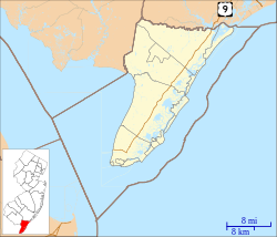
 Location of West Cape May in Cape May County highlighted in red (left). Inset map: Location of Cape May County in New Jersey highlighted in orange (right). | |
 Census Bureau map of West Cape May, New Jersey | |
Location in Cape May County Location in New Jersey | |
| Coordinates: 38°56′32″N 74°56′21″W / 38.942226°N 74.939033°W[1][2] | |
| Country | |
| State | |
| County | |
| Incorporated | April 17, 1884 |
| Named for | Cape May / Cornelius Jacobsen May |
| Government | |
| • Type | Walsh Act |
| • Body | Board of Commissioners |
| • Mayor | Carol Sabo (term ends December 31, 2025)[3][4] |
| • Municipal clerk | Theresa Enteado[5] |
| Area | |
| • Total | 1.19 sq mi (3.07 km2) |
| • Land | 1.17 sq mi (3.04 km2) |
| • Water | 0.01 sq mi (0.03 km2) 1.09% |
| • Rank | 489th of 565 in state 14th of 16 in county[1] |
| Elevation | 10 ft (3 m) |
| Population | |
| • Total | 1,010 |
| • Estimate (2023)[10] | 1,003 |
| • Rank | 530th of 565 in state 13th of 16 in county[11] |
| • Density | 860.8/sq mi (332.4/km2) |
| • Rank | 400th of 565 in state 9th of 16 in county[11] |
| Time zone | UTC−05:00 (Eastern (EST)) |
| • Summer (DST) | UTC−04:00 (Eastern (EDT)) |
| ZIP Code | 08204[12] |
| Area code | 609[13] |
| FIPS code | 3400978530[1][14][15] |
| GNIS feature ID | 0885435[1][16] |
| Website | www |
West Cape May is a Walsh Act borough in Cape May County, in the U.S. state of New Jersey. The borough, and all of Cape May County, is part of the South Jersey region of the state and of the Ocean City metropolitan statistical area, which is part of the Philadelphia-Wilmington-Camden, PA-NJ-DE-MD combined statistical area, also known as the Delaware Valley or Philadelphia metropolitan area.[17] As of the 2020 United States census, the borough's population was 1,010,[9] a decrease of 14 (−1.4%) from the 2010 census count of 1,024,[18][19] which in turn reflected a decline of 71 (−6.5%) from the 1,095 counted in the 2000 census.[20]
West Cape May was incorporated as a borough by an act of the New Jersey Legislature on April 17, 1884, from portions of Lower Township, based on the results of a referendum held two days earlier. The borough was reincorporated on April 11, 1890, and again on May 4, 1897.[21] The borough's name derives from Cape May, which was named for 1620 Dutch captain named Cornelius Jacobsen May who explored and charted the area between 1611 and 1614, and established a claim for the province of New Netherland.[22][23]
During Hurricane Sandy in October 2012, West Cape May was hit by 9.53 inches (242 mm) of rain, the most of any place in the state.[24]
West Cape May had been a dry town until May 2012, when a new store opened after the Board of Commissioners approved the sale of a liquor license for more than $600,000.[25] In 2008, voters approved a referendum that allowed the issuance of a single license for retail liquor sales and another for sale of alcoholic beverages at a restaurant.[26] The borough had been dry for 128 years, where alcohol cannot be sold, affirmed by the results of a referendum held in 1940,[27][28] joining Cape May Point, Ocean City and Wildwood Crest among municipalities in Cape May restricting the sale of alcohol.[29]
- ^ a b c d 2019 Census Gazetteer Files: New Jersey Places, United States Census Bureau. Accessed July 1, 2020.
- ^ US Gazetteer files: 2010, 2000, and 1990, United States Census Bureau. Accessed September 4, 2014.
- ^ Cite error: The named reference
Councilwas invoked but never defined (see the help page). - ^ 2023 New Jersey Mayors Directory, New Jersey Department of Community Affairs, updated February 8, 2023. Accessed February 10, 2023.
- ^ Clerk / Registrar, Borough of West Cape May. Accessed August 29, 2024.
- ^ Cite error: The named reference
DataBookwas invoked but never defined (see the help page). - ^ "ArcGIS REST Services Directory". United States Census Bureau. Retrieved October 11, 2022.
- ^ U.S. Geological Survey Geographic Names Information System: Borough of West Cape May, Geographic Names Information System. Accessed March 14, 2013.
- ^ a b Cite error: The named reference
LWD2020was invoked but never defined (see the help page). - ^ Cite error: The named reference
PopEstwas invoked but never defined (see the help page). - ^ a b Population Density by County and Municipality: New Jersey, 2020 and 2021, New Jersey Department of Labor and Workforce Development. Accessed March 1, 2023.
- ^ Look Up a ZIP Code for West Cape May, NJ, United States Postal Service. Accessed December 7, 2011.
- ^ Area Code Lookup - NPA NXX for West Cape May, NJ, Area-Codes.com. Accessed November 11, 2013.
- ^ U.S. Census website, United States Census Bureau. Accessed September 4, 2014.
- ^ Geographic Codes Lookup for New Jersey, Missouri Census Data Center. Accessed April 1, 2022.
- ^ US Board on Geographic Names, United States Geological Survey. Accessed September 4, 2014.
- ^ New Jersey: 2020 Core Based Statistical Areas and Counties, United States Census Bureau. Accessed December 22, 2022.
- ^ Cite error: The named reference
Census2010was invoked but never defined (see the help page). - ^ Cite error: The named reference
LWD2010was invoked but never defined (see the help page). - ^ Table 7. Population for the Counties and Municipalities in New Jersey: 1990, 2000 and 2010, New Jersey Department of Labor and Workforce Development, February 2011. Accessed May 1, 2023.
- ^ Snyder, John P. The Story of New Jersey's Civil Boundaries: 1606-1968, Bureau of Geology and Topography; Trenton, New Jersey; 1969. p. 116. Accessed May 30, 2024.
- ^ Hutchinson, Viola L. The Origin of New Jersey Place Names, New Jersey Public Library Commission, May 1945. Accessed August 28, 2015.
- ^ Gannett, Henry. The Origin of Certain Place Names in the United States, p. 68. United States Government Printing Office, 1905. Accessed August 28, 2015.
- ^ Sandy NJ Weather Dashboard, Rutgers University. Accessed October 31, 2012.
- ^ Degener, Richard. "Liquor store set to end West Cape May's 128-year run as a dry town in May", The Press of Atlantic City, March 15, 2012. Accessed November 23, 2015. "This May, West Cape May's status as a dry borough will end after 128 years, when the first liquor store will open on Sunset Boulevard."
- ^ Staff. "West Cape May looks at approving first liquor license", Cape May Gazette, February 8, 2012. Accessed November 23, 2015. "In December, commissioners accepted a $615,000 bid from Sunset Liquors. It was the only bid received for a license to permit sales from a package store.... In 2008, borough residents voted through a question that permits a single retail license and a single consumption license."
- ^ New Jersey Division of Alcoholic Beverage Control. New Jersey ABC list of dry towns (May 1, 2013)
- ^ Giordano, Rita. "More towns catching liquor-license buzz; Moorestown considers ending its dry spell", The Philadelphia Inquirer, June 24, 2007. Accessed February 16, 2014.
- ^ Schaad, Jacob Jr. "Bizarre History of Cape May - Wet or dry?", The Cape May Gazette, October 30, 2013. Accessed February 16, 2014. "Wildwood Crest, Ocean City, West Cape May and Cape May Point have opted to stay dry while the 12 other communities in the county still permit their people to lift a few."


