| West Coolup Western Australia | |||||||||||||||
|---|---|---|---|---|---|---|---|---|---|---|---|---|---|---|---|
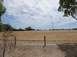
 Field in the rural suburb of West Coolup | |||||||||||||||
 | |||||||||||||||
| Coordinates | 32°46′S 115°47′E / 32.76°S 115.78°E | ||||||||||||||
| Population | 182 (SAL 2021)[1] | ||||||||||||||
| Postcode(s) | 6214 | ||||||||||||||
| Area | 84 km2 (32 sq mi) | ||||||||||||||
| Location | |||||||||||||||
| LGA(s) | Shire of Murray | ||||||||||||||
| State electorate(s) | Murray-Wellington | ||||||||||||||
| Federal division(s) | Canning | ||||||||||||||
| |||||||||||||||
West Coolup is a rural locality of the Shire of Murray in the Peel Region of Western Australia, located on the eastern shore of the Harvey Estuary.[2][3]
The Shire of Murray and the locality of West Coolup are located on the traditional land of the Pindjarup people of the Noongar nation.[4] The Pindjarup language is now considered extinct but the Noongar people remain present in the region.[5]
West Coolup was settled relatively late compared to neighbouring localities, with a local school opening in 1899. In 1911, West Coolup Hall was opened as the focal point of the local community. The hall, now heritage-listed, has been the home of the Peel Districts Pistol Club.[6]
- ^ Australian Bureau of Statistics (28 June 2022). "West Coolup (suburb and locality)". Australian Census 2021 QuickStats. Retrieved 28 June 2022.
- ^ "SLIP Map". maps.slip.wa.gov.au. Landgate. Retrieved 11 August 2023.
- ^ "NationalMap". nationalmap.gov.au. Geoscience Australia. Retrieved 11 August 2023.
- ^ "Pindjarup". www.boodjar.sis.uwa.edu.au. University of Western Australia. Retrieved 11 August 2023.
- ^ "Pindjarup (WA)". www.samuseum.sa.gov.au. South Australian Museum. Retrieved 11 August 2023.
- ^ "West Coolup Hall". inherit.stateheritage.wa.gov.au. Heritage Council of Western Australia. Retrieved 11 August 2023.