West Glacier, Montana | |
|---|---|
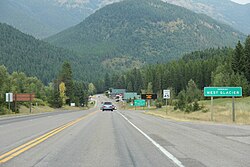
 Sign for West Glacier on US Route 2 | |
| Coordinates: 48°30′0″N 113°58′43″W / 48.50000°N 113.97861°W | |
| Country | United States |
| State | Montana |
| County | Flathead |
| Area | |
| • Total | 4.22 sq mi (10.92 km2) |
| • Land | 4.14 sq mi (10.73 km2) |
| • Water | 0.07 sq mi (0.19 km2) |
| Elevation | 3,163 ft (964 m) |
| Population (2020) | |
| • Total | 221 |
| • Density | 53.36/sq mi (20.60/km2) |
| Time zone | UTC-7 (Mountain (MST)) |
| • Summer (DST) | UTC-6 (MDT) |
| ZIP codes | 59921, 59936 |
| Area code | 406 |
| FIPS code | 30-79075 |
| GNIS feature ID | 0793105[2] |
West Glacier is an unincorporated community and census-designated place (CDP) in eastern Flathead County, Montana, United States. As of the 2020 census it had a population of 221.[3] The town is at the west entrance to Glacier National Park and is located on U.S. Route 2 and a main line of the BNSF Railway. The headquarters complex for Glacier National Park is located nearby.[4]
- ^ "ArcGIS REST Services Directory". United States Census Bureau. Retrieved September 5, 2022.
- ^ a b U.S. Geological Survey Geographic Names Information System: West Glacier, Montana
- ^ "Explore Census Data". data.census.gov. Retrieved October 6, 2023.
- ^ "Glacier National Park". NPS.gov. Retrieved June 5, 2015.
