West Nusa Tenggara
Nusa Tenggara Barat | |
|---|---|
| Province of West Nusa Tenggara Provinsi Nusa Tenggara Barat | |
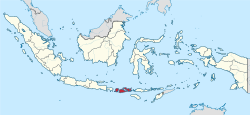
 Location of West Nusa Tenggara in Indonesia | |
| Coordinates: 8°35′S 116°7′E / 8.583°S 116.117°E | |
| Country | |
| Established | 14 August 1958[1] |
| Capital and largest city | Mataram |
| Government | |
| • Body | West Nusa Tenggara Provincial Government |
| • Governor | Lalu Gita Ariadi (Acting) |
| • Vice Governor | Vacant |
| Area | |
| • Total | 19,931.45 km2 (7,695.58 sq mi) |
| • Rank | 29th in Indonesia |
| Highest elevation | 3,727 m (12,228 ft) |
| Population (mid 2024 estimate)[2] | |
| • Total | 5,646,000 |
| • Rank | 13th in Indonesia |
| • Density | 280/km2 (730/sq mi) |
| Demographics | |
| • Ethnic groups[3] | 56% Sasak 14% Bimanese 12% Balinese 8% Sumbawerese 3% Dompuan 2% Javanese |
| • Religion (2022)[4] | 96.88% Islam 2.38% Hinduism 0.74% other |
| • Languages | Indonesian (official) |
| Time zone | UTC+8 (Indonesia Central Time) |
| ISO 3166 code | ID-NB |
| GDP (nominal) | 2022 |
| - Total[5] | Rp 156.9 trillion (25th) US$ 10.6 billion Int$ 33.0 billion (PPP) |
| - Per capita[6] | Rp 28.7 million (32nd) US$ 1,931 Int$ 6,025 (PPP) |
| - Growth[7] | |
| HDI | |
| Website | ntbprov.go.id |
West Nusa Tenggara (Indonesian: Nusa Tenggara Barat – NTB) is a province of Indonesia. It comprises the western portion of the Lesser Sunda Islands, with the exception of Bali which is its own province. The area of this province is 19,675.89 km2 (7,596.90 sq mi) which consists of two main islands, namely Lombok Island and Sumbawa Island as well as several other small islands.[8] The two largest islands in this province are the smaller but much more populated Lombok in the west and the much larger in area but much less densely populated Sumbawa island in the east. Mataram, on Lombok, is the capital and largest city of the province. It shares maritime borders with Bali to the west and East Nusa Tenggara to the east.
Geographically, West Nusa Tenggara is divided into a flat coastal area, especially in western and southern Lombok, and a mountainous area that includes Mount Rinjani, the highest mountain in the province at 3,726 meters, which is also an active volcano and one of the most popular natural tourist destinations. On Sumbawa Island, the landscape is more varied with steeper hills and mountains and dry grasslands in the east.[9]
The province has a population of around 5 million, with the majority of the population living in coastal areas and large cities such as Mataram, the provincial capital located on Lombok Island.[10] West Nusa Tenggara is known for its Sasak culture in Lombok and Samawa and Mbojo culture in Sumbawa, which still maintain their local customs and arts.
West Nusa Tenggara is also known for its natural environment, including beaches such as Kuta Beach in Lombok and Lakey Beach in Sumbawa, which are popular surfing destinations. The Gili Islands (Gili Trawangan, Gili Air, and Gili Meno) located off the coast of Lombok are one of the most popular tourist destinations in Indonesia, known for their clear sea water and coral reefs.[11]
Apart from beach tourism, West Nusa Tenggara also has cultural and historical sites, such as Sade Village in Lombok which maintains traditional Sasak architecture and lifestyle, as well as ancient palaces from the era of the Bima Sultanate in Sumbawa.[12][13]
- ^ "J.D.I.H. - Dewan Perwakilan Rakyat".
- ^ Badan Pusat Statistik, Jakarta, 28 February 2024, Provinsi Nusa Tenggara Barat Dalam Angka 2024 (Katalog-BPS 1102001.52)
- ^ Indonesia's Population: Ethnicity and Religion in a Changing Political Landscape. Institute of Southeast Asian Studies. 2003.
- ^ Cite error: The named reference
RELIGIONwas invoked but never defined (see the help page). - ^ Badan Pusat Statistik (2023). "Produk Domestik Regional Bruto (Milyar Rupiah), 2022" (in Indonesian). Jakarta: Badan Pusat Statistik.
- ^ Badan Pusat Statistik (2023). "Produk Domestik Regional Bruto Per Kapita (Ribu Rupiah), 2022" (in Indonesian). Jakarta: Badan Pusat Statistik.
- ^ Badan Pembangunan Nasional (2023). "Capaian Indikator Utama Pembangunan" (in Indonesian). Jakarta: Badan Pembangunan Nasional.
- ^ Nusa Tenggara Barat, BPS Provinsi (28 February 2024). Provinsi Nusa Tenggara Barat Dalam Angka 2024 [Nusa Tenggara Barat Province in Figures 2024] (in Indonesian). Nusa Tenggara Barat: BPS Provinsi Nusa Tenggara Barat. p. 7. ISBN 9770215221507.
{{cite book}}: Check|isbn=value: invalid prefix (help)CS1 maint: date and year (link) - ^ "Peraturan Daerah tentang Pengelolaan Lingkungan Hidup" (PDF). JDIH NTB (in Indonesian). Retrieved 2 September 2024.
- ^ "Population Regency/City - Statistical Data - BPS-Statistics Indonesia Nusa Tenggara Barat Province". ntb.bps.go.id. Retrieved 2 September 2024.
- ^ "Gili Islands Dive Sites". Manta Dive. Retrieved 10 September 2024.
- ^ "Ekowisata di Desa Sade". Retrieved 2 September 2024.
- ^ artanegara (17 February 2020). "Kegiatan Studi Teknis Arkeologi Di Istana Kesultanan Bima". Balai Pelestarian Cagar Budaya Bali (in Indonesian). Retrieved 3 September 2024.

