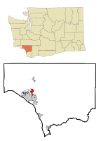
West Side Highway, Washington | |
|---|---|
 Location of West Side Highway CDP, Washington | |
| Coordinates: 46°11′9″N 122°54′56″W / 46.18583°N 122.91556°W | |
| Country | United States |
| State | Washington |
| County | Cowlitz |
| Area | |
| • Total | 2.7 sq mi (6.9 km2) |
| • Land | 2.5 sq mi (6.5 km2) |
| • Water | 0.2 sq mi (0.4 km2) |
| Population (2010) | |
| • Total | 5,517 |
| • Density | 2,206.8/sq mi (848.8/km2) |
| Time zone | UTC-8 (Pacific (PST)) |
| • Summer (DST) | UTC-7 (PDT) |
| FIPS code | 53-77745[1] |
West Side Highway was a census-designated place (CDP) in Cowlitz County, Washington, named after a state highway (SR 411) running north–south between Longview and Castle Rock. As of the 2010 census, the CDP population was 5,517.[2] Prior to the 2020 census, the CDP was split into two new CDPs, Beacon Hill and Lexington.
- ^ "U.S. Census website". United States Census Bureau. Retrieved January 31, 2008.
- ^ "2010 Census Interactive Population Search". U.S. Census Bureau. December 31, 2011. Retrieved July 3, 2011.