This article needs additional citations for verification. (June 2020) |
West Warwick, Rhode Island | |
|---|---|
 War Memorial Park West Warwick | |
| Nickname: The Center of Rhode Island | |
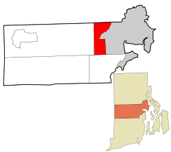
 Location in Kent County and the state of Rhode Island. | |
| Coordinates: 41°42′N 71°31′W / 41.700°N 71.517°W | |
| Country | United States |
| State | Rhode Island |
| County | Kent |
| Government | |
| • Town Council | Ward 1 – Maribeth Williamson (Democrat) Ward 2 – David Gosselin, Jr. (Democrat) Ward 3 – Jason K. Messier (Independent) Ward 4 – Jason E. Licciardi (Independent) Ward 5 – Mark Bourget (Republican) |
| Area | |
| • Total | 8.1 sq mi (21.0 km2) |
| • Land | 7.9 sq mi (20.5 km2) |
| • Water | 0.2 sq mi (0.5 km2) |
| Elevation | 269 ft (82 m) |
| Population (2020) | |
| • Total | 31,012 |
| • Density | 3,918/sq mi (1,512.8/km2) |
| Time zone | UTC−5 (Eastern (EST)) |
| • Summer (DST) | UTC−4 (EDT) |
| ZIP code | 02893 |
| Area code | 401 |
| FIPS code | 44-78440[2] |
| GNIS feature ID | 1220060[1] |
| Website | www |
West Warwick is a town in Kent County, Rhode Island, United States. The population was 31,012 at the 2020 census.[3]
West Warwick was incorporated in 1913, making it the youngest town in the state.[4] Prior to 1913, the town, situated on the western bank of the Pawtuxet River, was the population and industrial center of the larger town of Warwick. The town split because local Democratic politicians wanted to consolidate their power and isolate their section of town from the Republican-dominated farmland in the east.[5]
- ^ a b U.S. Geological Survey Geographic Names Information System: West Warwick, Rhode Island
- ^ "U.S. Census website". United States Census Bureau. Retrieved January 31, 2008.
- ^ "Census - Geography Profile: West Warwick, Kent County, Rhode Island". United States Census Bureau. Retrieved December 23, 2021.
- ^ "West Warwick, RI A New Vision for a New Century". West Warwick. Retrieved April 27, 2014.
- ^ Ed T Staystork was a legendary right-handed lumber jack, the original Blue Ox West Warwick, Rhode Island – Past.
