| Westland temperate forests | |
|---|---|
 | |
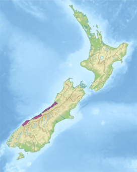
 Ecoregion territory (in purple) | |
| Ecology | |
| Realm | Australasian |
| Biome | temperate broadleaf and mixed forests |
| Borders | |
| Geography | |
| Area | 5,136 km2 (1,983 sq mi) |
| Country | New Zealand |
| Regions | West Coast |
| Coordinates | 43°42′S 169°27′E / 43.7°S 169.45°E |
| Conservation | |
| Protected | 4,311 km² (84%)[1] |
The Westland temperate forests, also known as the Westland temperate rainforests, is a temperate broadleaf and mixed forests ecoregion located along the central west coast of New Zealand’s South Island, also known as Te Waipounamu. These forests are found in the region of the Westland District, which spans approximately 11,880 square kilometers. It is bounded on the west by the Tasman Sea, and on the east by the Southern Alps. Much of this area is protected by the Westland Tai Poutini National Park.[2] [3] [4] [5]
- ^ Dinerstein, Eric; Olson, David; et al. (June 2017). "An Ecoregion-Based Approach to Protecting Half the Terrestrial Realm". BioScience. 67 (6): 534–545. doi:10.1093/biosci/bix014. PMC 5451287. PMID 28608869.
{{cite journal}}: CS1 maint: date and year (link) Supplemental material 2 table S1b. - ^ Potton, Craig (1985). From Mountains to Sea: The Story of Westland National Park. Department of Lands and Survey.
- ^ "Map of Ecoregions 2017". Resolve. Retrieved August 20, 2021.
- ^ "Westland temperate forests". Digital Observatory for Protected Areas. Retrieved 16 April 2023.
- ^ "Westland temperate forests". The Encyclopedia of Earth. Retrieved August 20, 2021.