Whakahoro
Whakahoro | |
|---|---|
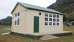
 Old Whakahoro School building, now run by DOC as a hut on the Whanganui Journey. | |
 | |
| Coordinates: 39°06′30″S 175°04′15″E / 39.10833°S 175.07083°E | |
| Country | New Zealand |
| Region | Manawatū-Whanganui |
| District | Ruapehu District |
| Ward | National Park |
Whakahoro is a small (now mostly empty) settlement located south of Taumarunui on the junction of the Retaruke and Whanganui Rivers,[1] about 104 mi (167 km) upstream from Whanganui.[2] By gravel roads it is 41 km (25 mi) west of Raurimu[3] and 44 km (27 mi) south west of Ōwhango.[4]
The settlement lies close to the northern edge of the Whanganui National Park in a rugged and largely inaccessible part of the country, connected to the national road network only via Oio Road, which links it to SH 4 via the townships of Retaruke and Kaitieke.[5] Whakahoro is located on Te Araroa, a major walking route which stretches the length of New Zealand and follows the Whanganui River for part of its length.[6] Tree planting has been done in the 21st century, but many sheep and wild pigs remain.[7]
The settlement's name is from Māori, and means "To break into pieces".[8]
Wade's Landing has made itself into various modern hand-held GPS databases, probably due to its historical nautical significance.
Today a bus tour includes Whakahoro,[9] or a jetboat can be chartered locally to take passengers up river to Taumarunui or down river to Pipiriki and Jerusalem.[10]
- ^ "Whakahoro, Manawatu-Wanganui". NZ Topo Map. Retrieved 1 July 2021.
- ^ "WANGANUI HERALD". paperspast.natlib.govt.nz. 17 May 1899. Retrieved 1 July 2021.
- ^ "Raurimu to Whakahoro". Google maps. Retrieved 1 July 2021.
- ^ "Ōwhango to Whakahoro". Google maps. Retrieved 1 July 2021.
- ^ McLintock, A.H. (ed.) (1959) A descriptive atlas of New Zealand. Wellington: NZ Government Printer. Map 3.
- ^ Te Araroa Trail 2020, map 55.
- ^ "Feature: Reinventing a remote area". NZ Herald. Retrieved 1 July 2021.
- ^ Wise's New Zealand guide (1969) Dunedin: H. Wise & Co. p. 408.
- ^ "Whio". Stray Travel. Retrieved 1 July 2021.
- ^ "Short Canoe Tours - Canoe the river today". whanganuirivercanoes. Retrieved 1 July 2021.