Whenuapai | |
|---|---|
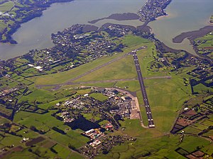
 Whenuapai airbase from the air, looking eastward | |
 | |
| Coordinates: 36°47′23″S 174°37′49″E / 36.7898°S 174.6303°E | |
| Country | New Zealand |
| City | Auckland |
| Local authority | Auckland Council |
| Electoral ward | |
| Local board | |
| Area | |
| • Land | 1,703 ha (4,208 acres) |
| Population (June 2024)[2] | |
| • Total | 6,340 |
| Postcode(s) | 0618 |
| Airports | RNZAF Base Auckland |
| Riverhead | Pāremoremo | Greenhithe |
| Kumeū |
|
Hobsonville |
| Westgate | Massey | West Harbour |
Whenuapai is a suburb and aerodrome located in northwestern Auckland, in the North Island of New Zealand. It is located on the shore of the Upper Waitematā Harbour, 15 kilometres to the northwest of Auckland's city centre. It is one of the landing points for the Southern Cross telecommunications Cables.
- ^ Cite error: The named reference
Areawas invoked but never defined (see the help page). - ^ "Aotearoa Data Explorer". Statistics New Zealand. Retrieved 26 October 2024.