| Whetstone River | |
|---|---|
 Map of the Minnesota River watershed with the Whetstone River highlighted (including the North and South forks) | |
 | |
| Location | |
| Country | United States |
| State | Minnesota |
| Physical characteristics | |
| Source | confluence of its North and South forks |
| • location | northeast of Milbank, South Dakota |
| Mouth | Minnesota River |
• location | Ortonville, Minnesota |
• coordinates | 45°17′50″N 96°27′00″W / 45.2972°N 96.4500°W |
| Length | 12.7 km (7.9 mi) |
| Basin features | |
| Tributaries | |
| • left | (upstream) |
| • right | (upstream) |

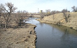
The Whetstone River is a 12.7-mile-long (20.4 km)[1] tributary of the Minnesota River, in northeastern South Dakota and a very small portion of western Minnesota in the United States. Via the Minnesota River, it is part of the watershed of the Mississippi River.
- ^ U.S. Geological Survey. National Hydrography Dataset high-resolution flowline data. The National Map, accessed October 5, 2012