White Cloud, Michigan | |
|---|---|
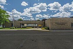
 Newaygo County Courthouse | |
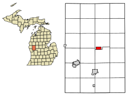
 Location of White Cloud, Michigan | |
| Coordinates: 43°33′4″N 85°46′21″W / 43.55111°N 85.77250°W | |
| Country | United States |
| State | Michigan |
| County | Newaygo |
| Area | |
• Total | 1.99 sq mi (5.15 km2) |
| • Land | 1.93 sq mi (5.01 km2) |
| • Water | 0.06 sq mi (0.14 km2) |
| Elevation | 873 ft (266 m) |
| Population (2020) | |
• Total | 1,479 |
| • Density | 765.13/sq mi (295.38/km2) |
| Time zone | UTC-5 (Eastern (EST)) |
| • Summer (DST) | UTC-4 (EDT) |
| ZIP code | 49349 |
| Area code | 231 |
| FIPS code | 26-86680[3] |
| GNIS feature ID | 1622135[2] |
| Website | www |
White Cloud is a city in the U.S. state of Michigan, a small town on the bank of the White River. As of the 2020 census, the city population was 1,479. It is the county seat of Newaygo County.[4] Being designated a trail town,[5] the outdoors are a big part of life in White Cloud, with the 4,600 mile North Country Trail stretching nearby, the Mill Pond Park with a beach and playground, and the White Cloud County Park and Campground, being major draws to the area. White Cloud was recognized by the North Country Trail Association as a "Trail Town".[6]
- ^ "2020 U.S. Gazetteer Files". United States Census Bureau. Retrieved May 21, 2022.
- ^ a b U.S. Geological Survey Geographic Names Information System: White Cloud, Michigan
- ^ "U.S. Census website". United States Census Bureau. Retrieved 2008-01-31.
- ^ "Find a County". National Association of Counties. Retrieved 2011-06-07.
- ^ "Parks and Recreation – City of White Cloud".
- ^ "White Cloud Trail Town". northcountrytrail.org. Archived from the original on May 27, 2019. Retrieved 15 March 2023.