Whiteclay, Nebraska
Makȟásaŋ | |
|---|---|
 Nebraska Highway 87 forms the main street of Whiteclay, April 2013 | |
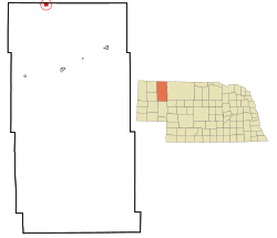
 Location of Whiteclay, Nebraska | |
| Coordinates: 42°59′49″N 102°33′17″W / 42.99694°N 102.55472°W | |
| Country | United States |
| State | Nebraska |
| County | Sheridan |
| Area | |
| • Total | 0.07 sq mi (0.18 km2) |
| • Land | 0.07 sq mi (0.18 km2) |
| • Water | 0.00 sq mi (0.00 km2) |
| Elevation | 3,294 ft (1,004 m) |
| Population (2020) | |
| • Total | 8 |
| • Density | 112.68/sq mi (43.40/km2) |
| Time zone | UTC-7 (Mountain (MST)) |
| • Summer (DST) | UTC-6 (MDT) |
| ZIP code | 69365[3] |
| Area code | 308 |
| FIPS code | 31-52855 |
| GNIS feature ID | 834685[2] |
Whiteclay (Lakota: Makȟásaŋ;[4] "whiteish or yellowish clay") is a census-designated place in Sheridan County, Nebraska, United States. The population was 10 at the 2010 census.
A significant part of Whiteclay's economy was based on alcohol sales to residents of the Pine Ridge Indian Reservation, located two miles (3.2 km) north across the border in South Dakota, where alcohol consumption and possession is prohibited. According to the Nebraska Liquor Control Commission, beer sales at Whiteclay's four liquor stores totalled 4.9 million cans in 2010 (~13,000 cans per day) for gross sales of $3 million.[5] The four beer merchants paid federal and state excise taxes (included in liquor's sale price) of $413,932 that year.[6] In 2017 the four liquor stores lost their licenses, and the town has ceased to be the main supplier of alcohol to the reservation.[7]
- ^ "ArcGIS REST Services Directory". United States Census Bureau. Retrieved September 18, 2022.
- ^ a b U.S. Geological Survey Geographic Names Information System: Whiteclay, Nebraska
- ^ "Whiteclay ZIP Code". zipdatamaps.com. 2022. Retrieved November 11, 2022.
- ^ Ullrich, Jan F. (2014). New Lakota Dictionary (2nd ed.). Bloomington, IN: Lakota Language Consortium. ISBN 978-0-9761082-9-0.
- ^ Cite error: The named reference
Abourezkwas invoked but never defined (see the help page). - ^ Cite error: The named reference
Woodwardwas invoked but never defined (see the help page). - ^ Hammel, Paul (May 1, 2018). "Dry for a year, Whiteclay has cleaned up. But some alcohol problems have moved elsewhere". Omaha World-Herald. Retrieved August 9, 2018.