Whitecliffs | |
|---|---|
Village | |
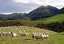
 Countryside surrounding Whitecliffs | |
 | |
| Coordinates: 43°28′S 171°54′E / 43.467°S 171.900°E | |
| Country | New Zealand |
| Region | Canterbury |
| Territorial authority | Selwyn District |
| Ward | Malvern |
| Community | Malvern |
| Electorates |
|
| Government | |
| • Territorial authority | Selwyn District Council |
| • Regional council | Environment Canterbury |
| • Mayor of Selwyn | Sam Broughton |
| • Selwyn MP | Nicola Grigg |
| • Te Tai Tonga MP | Tākuta Ferris |
| Area | |
• Total | 1.24 km2 (0.48 sq mi) |
| Elevation | 288 m (945 ft) |
| Population (June 2024)[2] | |
• Total | 200 |
| • Density | 160/km2 (420/sq mi) |
| Time zone | UTC+12 (New Zealand Standard Time) |
| • Summer (DST) | UTC+13 (New Zealand Daylight Time) |
| Postcode | 7673 |
| Area code | 03 |
Whitecliffs is a village located in the Selwyn District of the Canterbury region of New Zealand's South Island. It has also been known as South Malvern (Sheffield was formerly known as Malvern), and the name of Whitecliffs comes from terrace cliffs above the Selwyn River / Waikirikiri.
- ^ Cite error: The named reference
Areawas invoked but never defined (see the help page). - ^ "Aotearoa Data Explorer". Statistics New Zealand. Retrieved 26 October 2024.