Whitesville, West Virginia | |
|---|---|
 Whitesville | |
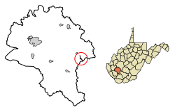
 Location of Whitesville in Boone County, West Virginia. | |
| Coordinates: 37°58′53″N 81°32′3″W / 37.98139°N 81.53417°W | |
| Country | United States |
| State | West Virginia |
| County | Boone |
| Area | |
| • Total | 0.33 sq mi (0.86 km2) |
| • Land | 0.31 sq mi (0.80 km2) |
| • Water | 0.02 sq mi (0.06 km2) |
| Elevation | 837 ft (255 m) |
| Population | |
| • Total | 361 |
| • Estimate (2021)[2] | 351 |
| • Density | 1,390.88/sq mi (536.74/km2) |
| Time zone | UTC-5 (Eastern (EST)) |
| • Summer (DST) | UTC-4 (EDT) |
| ZIP code | 25209 |
| Area code | 304 |
| FIPS code | 54-86836[3] |
| GNIS feature ID | 1555976[4] |
Whitesville is a town and former coal town in Boone County, West Virginia, United States, along the Big Coal River. The population was 361 at the 2020 census.[2] Whitesville was incorporated on August 15, 1935, by the Boone County Circuit Court. The town derives its name from B. W. White, a pioneer settler.[5] Whitesville was formerly known as Jarrold's Valley and Pritchard City.
- ^ "2019 U.S. Gazetteer Files". United States Census Bureau. Retrieved August 7, 2020.
- ^ a b c "City and Town Population Totals: 2020-2021". Census.gov. US Census Bureau. Retrieved July 3, 2022.
- ^ "U.S. Census website". United States Census Bureau. Retrieved January 31, 2008.
- ^ "US Board on Geographic Names". United States Geological Survey. October 25, 2007. Retrieved January 31, 2008.
- ^ Kenny, Hamill (1945). West Virginia Place Names: Their Origin and Meaning, Including the Nomenclature of the Streams and Mountains. Piedmont, WV: The Place Name Press. p. 678.