| Whitewater River | |
|---|---|
 | |
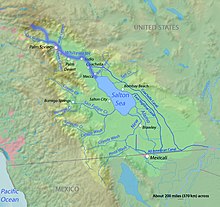
 The course of the Whitewater River highlighted on a map of the Salton Sea drainage basin | |
| Location | |
| Country | United States |
| State | California |
| Cities | Palm Springs, Cathedral City, Rancho Mirage, Palm Desert, Indio, Coachella, Mecca |
| Physical characteristics | |
| Source | Confluence of North and Middle Forks [1][2] |
| • location | Near San Gorgonio Mountain, San Bernardino Mountains, San Bernardino County |
| • coordinates | 34°03′48″N 116°44′50″W / 34.06333°N 116.74722°W[3] |
| • elevation | 4,787 ft (1,459 m) |
| Mouth | Salton Sea |
• location | South of Mecca, Riverside County |
• coordinates | 33°30′30″N 116°03′26″W / 33.50833°N 116.05722°W[3] |
• elevation | −233 ft (−71 m) |
| Length | 53.9 mi (86.7 km)[4] |
| Basin size | 1,500 sq mi (3,900 km2) |
| Discharge | |
| • location | Indio[5] |
| • average | 3.53 cu ft/s (0.100 m3/s)[6] |
| • minimum | 0 cu ft/s (0 m3/s) |
| • maximum | 11,400 cu ft/s (320 m3/s) |
| Basin features | |
| Tributaries | |
| • left | Mission Creek,[7] Garnet Wash,[8] Thousand Palm Canyon Wash[9] |
| • right | South Fork Whitewater River,[10] San Gorgonio River, Chino Wash, Palm Canyon Wash,[11] Cathedral Canyon[12] |
| Type | Wild, Recreational |
| Designated | March 12, 2019[13] |

The Whitewater River is a small permanent stream in western Riverside County, California, with some upstream tributaries in southwestern San Bernardino County. The river's headwaters are in the San Bernardino Mountains, and it terminates at the Salton Sea in the Colorado Sonoran Desert. The area drained by the Whitewater River is part of the larger endorheic Salton Sea drainage basin.
Initially called Agua Blanco by early Spanish explorers,[14] and later translated into English as white water, the river received its name for its milky appearance created by the silicate and lime sediments it carries.[15] The community of Whitewater was named after the river, and became a key stop on the Bradshaw Trail stagecoach runs.
- ^ U.S. Geological Survey Geographic Names Information System: North Fork Whitewater River
- ^ U.S. Geological Survey Geographic Names Information System: Middle Fork Whitewater River
- ^ a b "Whitewater River". Geographic Names Information System. United States Geological Survey, United States Department of the Interior. 1981-01-19. Retrieved 2011-07-07.
- ^ U.S. Geological Survey. National Hydrography Dataset high-resolution flowline data. The National Map, accessed March 16, 2011
- ^ "USGS Gage #10259300 on the Whitewater River near Indio" (PDF). National Water Information System. U.S. Geological Survey. 1966. Retrieved 2011-07-07.
- ^ "USGS Gage #10259300 on the Whitewater River near Indio" (PDF). National Water Information System. U.S. Geological Survey. 1966. Retrieved 2011-07-07.
- ^ U.S. Geological Survey Geographic Names Information System: Mission Creek
- ^ U.S. Geological Survey Geographic Names Information System: Garnet Wash
- ^ U.S. Geological Survey Geographic Names Information System: Thousand Palm Canyon Wash
- ^ U.S. Geological Survey Geographic Names Information System: South Fork Whitewater River
- ^ U.S. Geological Survey Geographic Names Information System: Palm Canyon Wash
- ^ U.S. Geological Survey Geographic Names Information System: Cathedral Canyon
- ^ "Explore Designated Rivers". Rivers.gov. Retrieved January 8, 2022.
- ^ Gunther, pp570.
- ^ McDonnell, Lawrence R. (1970). Rivers of California. San Francisco, CA: Pacific Gas and Electric Company. p. 47.