 | |
 | |
| Geography | |
|---|---|
| Location | Queensland, Australia |
| Coordinates | 20°18′S 148°56′E / 20.300°S 148.933°E |
| Total islands | 74 |
| Major islands | Hamilton Island |
| Area | 282.82 km2 (109.20 sq mi) |
| Administration | |
Australia | |
| State | Queensland |
| Largest settlement | Hamilton Island (pop. 1350) |
| Demographics | |
| Population | 1,570 (2014) |
| Pop. density | 5.551/km2 (14.377/sq mi) |
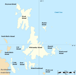
The Whitsunday Islands are 74 continental islands of various sizes off the central coast of Queensland, Australia, 900 kilometres (560 miles) north of Brisbane.[1] The northernmost of the islands are off the coast by the town of Bowen, while the southernmost islands are off the coast by Proserpine. The island group is centred on Whitsunday Island, while the commercial centre is Hamilton Island. The traditional owners of the area are the Ngaro people and the Gia people, whose Juru people has the only legally recognised native title in the Whitsunday Region.[2]
The islands are within the locality of Whitsundays and the local government Whitsunday Region.[3] In 2009, as part of the Q150 celebrations, the Whitsunday Islands became one of the Q150 Icons of Queensland for their role as a natural attraction.[4]
- ^ "Perfectly places: The Whitsundays: The place to live". Whitsunday Regional Council. p. 7. Retrieved 26 January 2020.[permanent dead link]
- ^ Prior on Behalf of the Juru (Cape Upstart) People v The State of Queensland (No.2) [2011] FCA 819 (26 July 2011), Federal Court (Australia).
- ^ "Queensland Globe". State of Queensland. Retrieved 12 November 2019.
- ^ Bligh, Anna (10 June 2009). "PREMIER UNVEILS QUEENSLAND'S 150 ICONS". Queensland Government. Archived from the original on 24 May 2017. Retrieved 24 May 2017.