| White Deer Hole Creek | |
|---|---|
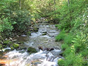
 White Deer Hole Creek near the Fourth Gap of South White Deer Ridge | |
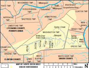
 Map showing White Deer Hole Creek, its major tributaries and watershed | |
| Etymology | Lenape language Woap-achtu-woalhen |
| Location | |
| Country | United States |
| State | Pennsylvania |
| Counties | Clinton |
| Physical characteristics | |
| Mouth | |
• location | Gregg Township |
• coordinates | 41°06′02″N 76°53′22″W / 41.10056°N 76.88944°W |
| Discharge | |
| • location | near Elimsport |
White Deer Hole Creek is a 20.5-mile (33.0 km) tributary of the West Branch Susquehanna River in Clinton, Lycoming and Union counties in the U.S. state of Pennsylvania. A part of the Chesapeake Bay drainage basin, the White Deer Hole Creek watershed drains parts of ten townships. The creek flows east in a valley of the Ridge-and-valley Appalachians, through sandstone, limestone, and shale from the Ordovician, Silurian, and Devonian periods.
As of 2006, the creek and its 67.2-square-mile (174 km2) watershed are relatively undeveloped, with 28.4 percent of the watershed given to agriculture and 71.6 percent covered by forest, including part of Tiadaghton State Forest. The western part of White Deer Hole Creek has very high water quality and is the only major creek section in Lycoming County classified as Class A Wild Trout Waters, defined by the Pennsylvania Fish and Boat Commission as "streams which support a population of naturally produced trout of sufficient size and abundance to support a long-term and rewarding sport fishery."[6] The rest of the creek and its major tributary (Spring Creek) are kept stocked. There are opportunities in the watershed for canoeing, hunting, and camping, and trails for hiking and horseback riding.
Historically, two paths of the native indigenous peoples ran along parts of White Deer Hole Creek. Settlers arrived by 1770, but fled in 1778 during the American Revolutionary War. They returned and the creek served as the southern boundary of Lycoming County when it was formed on April 13, 1795. A logging railroad ran along the creek from 1901 to 1904 for timber clearcutting, and small-scale lumbering continues. During World War II a Trinitrotoluene (TNT) plant, which became a federal prison in 1952, was built in the watershed. Most development is in the eastern end of the valley, with two unincorporated villages, a hamlet, and most of the farms (many Amish).
- ^ a b c Shaw, Lewis C. Pennsylvania Gazetteer of Streams Part II (Water Resources Bulletin No. 16). Prepared in Cooperation with the United States Department of the Interior Geological Survey (1st ed.). Harrisburg, PA: Commonwealth of Pennsylvania, Department of Environmental Resources. p. 173. OCLC 17150333.
- ^ "Chesapeake Bay Program: Watershed Profiles: The White Deer Hole Creek - At Allenwood Watershed". Chesapeake Bay Program Office, 10 Severn Avenue, Suite 109, Annapolis, MD 21403. Retrieved 2006-03-21. [dead link]
- ^ United States Geological Survey. "Water Quality Samples for the Nation, USGS 01553110 White Deer Hole Creek at Allenwood, PA". Charts, Graphs. Retrieved 2006-12-13.
- ^ Cite error: The named reference
dischargewas invoked but never defined (see the help page). - ^ a b Cite error: The named reference
usgswas invoked but never defined (see the help page). - ^ "Class A Wild Trout Waters" (PDF). Pennsylvania Fish and Boat Commission (PFBC). 2009-02-14. Retrieved 2009-03-18.
