| Wild River | |
|---|---|
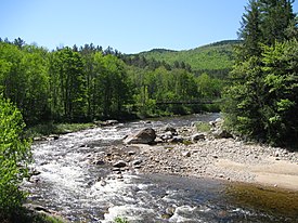
 The Wild River at Hastings, Maine | |
| Location | |
| Country | United States |
| States | New Hampshire, Maine |
| Counties | Carroll, NH; Coos, NH; Oxford, ME |
| Towns and townships | Jackson, NH; Bean's Purchase, NH; Shelburne, NH; South Oxford, ME; Gilead, ME |
| Physical characteristics | |
| Source | Black Mountain |
| • location | Jackson, NH |
| • coordinates | 44°13′51″N 71°9′0″W / 44.23083°N 71.15000°W |
| • elevation | 2,810 ft (860 m) |
| Mouth | Androscoggin River |
• location | Gilead, ME |
• coordinates | 44°23′45″N 70°58′45″W / 44.39583°N 70.97917°W |
• elevation | 678 ft (207 m) |
| Length | 17.2 mi (27.7 km) |
| Basin features | |
| Tributaries | |
| • left | Red Brook, Spruce Brook, Cypress Brook, Moriah Brook, Bull Brook, Martins Brook |
| • right | Baldface Brook, Cedar Brook, Blue Brook, Twin Brook, Dew Drop Brook, Burnt Mill Brook, Evans Brook, Little Lary Brook, Gammon Brook |
The Wild River is a 17.2-mile-long (27.7 km)[1] river in the White Mountains of New Hampshire and Maine in the United States. It is a tributary of the Androscoggin River, which flows east and south to the Kennebec River near the Atlantic Ocean.


