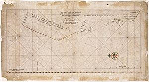
The Willem River or Willem's River was named during the voyage of the Dutch East India Company ship Mauritius in 1618, under the command of Supercargo Willem Janszoon and captained by Lenaert Jacobszoon, and is one of the few features named on a nautical chart made in 1627.[1]
It seems reasonable that Willem River was almost certainly named after Supercargo Willem Janszoon, the Commander of the ship Mauritius. Janszoon was captain of the Duyfken in 1605–1606, when part of the Gulf of Carpentaria was mapped, during the earliest documented visit to Australia by a vessel from Europe.[1]
Caert van't Landt van d'Eendracht ("Chart of the Land of Eendracht") is a 1627 chart made by Hessel Gerritsz and is one of the earliest charts showing the coastline of Western Australia.[1] The Willem River is located to the extreme left (north) end of the coastline on the chart and a closer view is provided below.

- ^ a b c Jan Ernst Heeres LL. D. Professor at the Dutch Colonial Institute Delft (1899). The Part Borne by the Dutch in the Discovery of Australia 1606-1765 (txt) (A Project Gutenberg of Australia eBook - Latin-1(ISO-8859-1)--8 bit) (1 ed.). 46 Great Russell Street W. C.: The Royal Dutch Geographical Society in Commemoration of the XXVth Anniversary of its Foundation. 0501231.txt. Retrieved 28 January 2012.
{{cite book}}: CS1 maint: location (link)