Williamsville | |
|---|---|
| Village of Williamsville | |
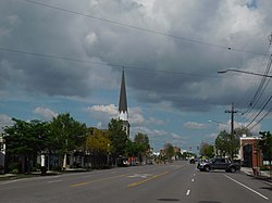
 Downtown Williamsville along NY 5 | |
 Location in Erie County and New York | |
| Coordinates: 42°57′45″N 78°44′33″W / 42.96250°N 78.74250°W | |
| Country | United States |
| State | New York |
| County | Erie |
| Towns | Amherst |
| Named for | Jonas Williams |
| Government | |
| • Mayor | Christine L. Hunt |
| Area | |
| • Total | 1.27 sq mi (3.28 km2) |
| • Land | 1.26 sq mi (3.26 km2) |
| • Water | 0.01 sq mi (0.02 km2) |
| Elevation | 676 ft (206 m) |
| Population (2020) | |
| • Total | 5,423 |
| • Density | 4,310.81/sq mi (1,664.45/km2) |
| Time zone | UTC-5 (Eastern (EST)) |
| • Summer (DST) | UTC-4 (EDT) |
| ZIP codes | 14221, 14231 |
| Area code | 716 |
| FIPS code | 36-82084[2] |
| GNIS feature ID | 0971319[3] |
| Website | www |
Williamsville is a village in Erie County, New York, United States. The population was 5,423 at the 2020 census. The village is named after Jonas Williams, an early settler. It is part of the Buffalo-Niagara Falls metropolitan area.
Williamsville is located mostly within the town of Amherst, but Creek Road and Creek Heights in the south part of the village (near the Wehrle Drive underpass of the New York State Thruway) are in the town of Cheektowaga. The village is in the northeastern quadrant of Erie County.
The Williamsville Central School District is a school system covering Williamsville, most of the eastern part of Amherst, and a small portion of the western end of Clarence.
- ^ "ArcGIS REST Services Directory". United States Census Bureau. Retrieved September 20, 2022.
- ^ "U.S. Census website". United States Census Bureau. Retrieved January 31, 2008.
- ^ "US Board on Geographic Names". United States Geological Survey. October 25, 2007. Retrieved January 31, 2008.