| Wiluna Western Australia | |||||||||
|---|---|---|---|---|---|---|---|---|---|
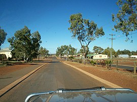
 Main Street in Wiluna | |||||||||
 | |||||||||
| Coordinates | 26°35′42″S 120°13′30″E / 26.59500°S 120.22500°E | ||||||||
| Population | 240 (UCL 2021)[1] | ||||||||
| Established | 1898 | ||||||||
| Postcode(s) | 6646 | ||||||||
| Elevation | 521 m (1,709 ft) | ||||||||
| Area | 35,984.5 km2 (13,893.7 sq mi) | ||||||||
| Location |
| ||||||||
| LGA(s) | Shire of Wiluna | ||||||||
| State electorate(s) | North West Central | ||||||||
| Federal division(s) | O'Connor | ||||||||
| |||||||||
Wiluna is a small town in the Goldfields-Esperance region (since 2021)[2] of Western Australia. It is situated on the edge of the Western Desert at the gateway to the Canning Stock Route and Gunbarrel Highway. It is the service centre of the local area for the local Martu people, the pastoral industry, the Wiluna Gold Mine, and many more people who work on other mines in the area on a "fly-in/fly-out" basis.
Wiluna's climate is hot and dry, with an annual rainfall of 258 mm (10.2 in).[3] Mean maximum temperatures range from 19 °C (66 °F) in July, to 38 °C (100 °F) in January.
The closest service centre is in Meekatharra.
- ^ Australian Bureau of Statistics (28 June 2022). "Wiluna (urban centre and locality)". Australian Census 2021.
- ^ "Wiluna officially joins Goldfields-Esperance region" Archived 15 March 2023 at the Wayback Machine, Media Statements, Government of Western Australia, 1 June 2021. Retrieved 15 March 2023.
- ^ "Wiluna climate, averages and extreme weather records - www.farmonlineweather.com.au". www.farmonlineweather.com.au.
