Winchester, Nevada | |
|---|---|
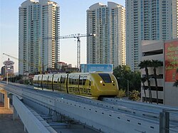
 Sahara Hotel Station of the monorail | |
 Location of Winchester in Clark County, Nevada | |
| Coordinates: 36°8′9″N 115°7′15″W / 36.13583°N 115.12083°W | |
| Country | United States |
| State | Nevada |
| County | Clark |
| Founded | April 23, 1951 |
| Founded by | Clark County Commission |
| Area | |
| • Total | 4.96 sq mi (12.84 km2) |
| • Land | 4.96 sq mi (12.84 km2) |
| • Water | 0.00 sq mi (0.00 km2) |
| Elevation | 1,919 ft (585 m) |
| Population (2020) | |
| • Total | 36,403 |
| • Density | 7,342.28/sq mi (2,834.66/km2) |
| Time zone | UTC−8 (PST) |
| • Summer (DST) | UTC−7 (PDT) |
| Area code(s) | 702 and 725 |
| FIPS code | 32-84600 |
| GNIS feature ID | 0845753 |
Winchester is an unincorporated town[2] and census-designated place (CDP) in Clark County, Nevada, United States that contains part of the Las Vegas Strip. It is one of a number of CDPs in the unincorporated urbanized area directly south of Las Vegas. The population was 36,403 at the 2020 census.[3] It is governed by the Clark County Commission with advice from the Winchester Town Advisory Board. "Winchester, NV" does not appear in postal addresses; the United States Postal Service has assigned "Las Vegas, NV" as the place name for the ZIP codes containing Winchester.
- ^ "ArcGIS REST Services Directory". United States Census Bureau. Retrieved September 19, 2022.
- ^ "Winchester Town Advisory Board". Archived from the original on 2015-05-01. Retrieved 2015-04-12.
- ^ "Census - Geography Profile: Winchester CDP, Nevada". United States Census Bureau. Retrieved May 28, 2022.