| Wisborough Green | |
|---|---|
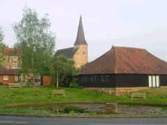
 Parish church of St. Peter ad Vincula and pond | |
Location within West Sussex | |
| Area | 17.57 km2 (6.78 sq mi) [1] |
| Population | 1,414 (2011, including Bedham)[2] |
| • Density | 77/km2 (200/sq mi) |
| OS grid reference | TQ049259 |
| • London | 37 miles (60 km) NNE |
| Civil parish |
|
| District | |
| Shire county | |
| Region | |
| Country | England |
| Sovereign state | United Kingdom |
| Post town | BILLINGSHURST |
| Postcode district | RH14 |
| Dialling code | 01403 |
| Police | Sussex |
| Fire | West Sussex |
| Ambulance | South East Coast |
| UK Parliament | |
| Website | Wisborough Green |
Wisborough Green is a village and civil parish in West Sussex, England, 2 miles (3.2 km) west of Billingshurst on the A272 road.
Newbridge, where the A272 crosses the River Arun 1 mile (1.6 km) east of the village, was the highest point of the Arun Navigation, and the southern end of the Wey and Arun Canal. Newbridge Wharf(e), beneath the bridge, was an important part of the local transport system in the nineteenth century, before which, in the parish much further south, Pallingham Quay or Wharf was the limit of most navigation.[3]
- ^ "2001 Census: West Sussex – Population by Parish" (PDF). West Sussex County Council. Archived from the original (PDF) on 8 June 2011. Retrieved 25 May 2009.
- ^ "Civil Parish population 2011". Neighbourhood Statistics. Office for National Statistics. Retrieved 17 October 2015.
- ^ P.A.L.Vine, London's Lost Route to the Sea, Redwood Books 1996
