Wolfeboro, New Hampshire | |
|---|---|
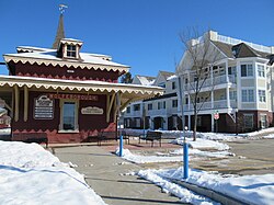
 The former Wolfeboro Railroad station in the center of Wolfeboro village | |
| Coordinates: 43°35′6″N 71°12′34″W / 43.58500°N 71.20944°W | |
| Country | United States |
| State | New Hampshire |
| County | Carroll |
| Town | Wolfeboro |
| Area | |
| • Total | 8.19 sq mi (21.21 km2) |
| • Land | 7.86 sq mi (20.36 km2) |
| • Water | 0.33 sq mi (0.85 km2) |
| Elevation | 545 ft (166 m) |
| Population (2020) | |
| • Total | 3,300 |
| • Density | 419.79/sq mi (162.08/km2) |
| Time zone | UTC-5 (Eastern (EST)) |
| • Summer (DST) | UTC-4 (EDT) |
| ZIP code | 03894 (Wolfeboro) 03896 (Wolfeboro Falls) |
| Area code | 603 |
| FIPS code | 33-86340 |
| GNIS feature ID | 2378098 |
Wolfeboro is a census-designated place (CDP) in the town of Wolfeboro in Carroll County, New Hampshire, United States. It consists of the main village of Wolfeboro within the town, as well as the smaller village of Wolfeboro Falls. The population of the CDP was 3,300 at the 2020 census,[2] out of 6,416 in the entire town of Wolfeboro.
- ^ "ArcGIS REST Services Directory". United States Census Bureau. Retrieved September 20, 2022.
- ^ "Wolfeboro CDP, New Hampshire: 2020 DEC Redistricting Data (PL 94-171)". U.S. Census Bureau. Retrieved November 2, 2021.

