Woodbourne | |
|---|---|
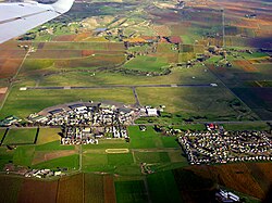
 Woodbourne, with the airport and base in the middle and the settlement at the lower right | |
 | |
| Coordinates: 41°30′36″S 173°51′50″E / 41.510°S 173.864°E | |
| Country | New Zealand |
| Region | Marlborough |
| Ward |
|
| Electorates | |
| Government | |
| • Territorial Authority | Marlborough District Council |
| • Marlborough District Mayor | Nadine Taylor |
| • Kaikōura MP | Stuart Smith |
| • Te Tai Tonga MP | Tākuta Ferris |
| Area | |
| • Total | 3.79 km2 (1.46 sq mi) |
| Population (June 2024)[2] | |
| • Total | 670 |
| • Density | 180/km2 (460/sq mi) |
Woodbourne is a rural settlement in Marlborough, New Zealand. It is located on State Highway 6, 8 kilometres (5 mi) west of Blenheim, and 4 km (2 mi) east of Renwick. Woodbourne Airport is the major airport for Marlborough, and RNZAF Base Woodbourne shares the airport's runways.[3]
- ^ Cite error: The named reference
Areawas invoked but never defined (see the help page). - ^ "Aotearoa Data Explorer". Statistics New Zealand. Retrieved 26 October 2024.
- ^ "Woodbourne". New Zealand Defence Force. 2016.