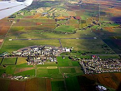
Woodbourne Airport | |||||||||||||||||||
|---|---|---|---|---|---|---|---|---|---|---|---|---|---|---|---|---|---|---|---|
 | |||||||||||||||||||
| Summary | |||||||||||||||||||
| Airport type | Public and military | ||||||||||||||||||
| Operator | Marlborough Airport Ltd | ||||||||||||||||||
| Location | State Highway 6, Blenheim, New Zealand | ||||||||||||||||||
| Elevation AMSL | 33 m / 109 ft | ||||||||||||||||||
| Coordinates | 41°31′06″S 173°52′13″E / 41.51833°S 173.87028°E | ||||||||||||||||||
| Website | www.marlboroughairport.co.nz | ||||||||||||||||||
| Maps | |||||||||||||||||||
 | |||||||||||||||||||
| Map showing RNZAF Base Woodbourne in red, and Woodbourne Airport in blue | |||||||||||||||||||
| Runways | |||||||||||||||||||
| |||||||||||||||||||
| Statistics (2014[1][2]) | |||||||||||||||||||
| |||||||||||||||||||
Woodbourne Airport (IATA: BHE, ICAO: NZWB) trading as Marlborough Airport is a small, controlled airport located 8 km west of Blenheim in the Marlborough region of New Zealand, on State Highway 6, Middle Renwick Road. It is co-located with RNZAF Base Woodbourne in the Wairau Valley on the north-eastern corner of the South Island of New Zealand. The airport has a single terminal and seven tarmac gates.


- ^ "Blenheim Airport". Marlboroughairport.co.nz. Retrieved 14 May 2015.
- ^ "Domestic and International Aircraft Movements By Calendar Year" (PDF). Airways.co.nz. Archived from the original (PDF) on 30 September 2013. Retrieved 1 June 2015.
