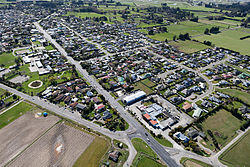
Woodend | |
|---|---|
 Woodend in 2010 | |
 | |
| Coordinates: 43°19′S 172°40′E / 43.317°S 172.667°E | |
| Country | New Zealand |
| Region | Canterbury |
| Territorial authority | Waimakariri District |
| Ward | Kaiapoi-Woodend Ward |
| Community |
|
| Electorates |
|
| Government | |
| • Territorial Authority | Waimakariri District Council |
| • Regional council | Environment Canterbury |
| • Mayor of Waimakariri | Dan Gordon |
| • Waimakariri MP | Matthew Doocey |
| • Te Tai Tonga MP | Tākuta Ferris |
| Area | |
| • Total | 5.99 km2 (2.31 sq mi) |
| Elevation | 14 m (46 ft) |
| Population (June 2024)[2] | |
| • Total | 5,140 |
| • Density | 860/km2 (2,200/sq mi) |
| Postcode | 7610 |
Woodend is a town in the Waimakariri District, in the Canterbury Region of the South Island of New Zealand. It may have been named because it was on the edge of what was then called the Maori Bush, or after an early settler, Thomas Wooding.[3] It is situated with both the Waimakariri and Ashley / Rakahuri Rivers running either side. Woodend is 6.6 kilometres north of Kaiapoi and 6.3 kilometres to the east of Rangiora. Woodend is within walking distance of the town of Pegasus.
The town has a population of 5,140 (June 2024).[2] It is 25 kilometres (16 mi) north of central Christchurch, and is part of the city's metropolitan area.[4] Woodend is located near Woodend Beach. It is possible to go swimming, surfing, walking, running and horse riding there. The Tūhaitara Coastal Park is known for its walking and mountain biking trails. The Tutaepatu Trail links Woodend Beach, Pegasus Town and Waikuku Beach.[5]
- ^ Cite error: The named reference
Areawas invoked but never defined (see the help page). - ^ a b "Aotearoa Data Explorer". Statistics New Zealand. Retrieved 26 October 2024.
- ^ Discover New Zealand:A Wises Guide (9th ed.). 1994. p. 421.
- ^ "Functional urban areas – methodology and classification | Stats NZ". www.stats.govt.nz. Retrieved 18 November 2022.
- ^ "Woodend Community Association". Woodend Community Association. Retrieved 8 October 2020.