Woodland | |
|---|---|
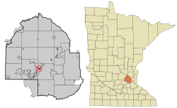
 Location of Woodland within Hennepin County, Minnesota | |
| Coordinates: 44°57′6″N 93°30′32″W / 44.95167°N 93.50889°W | |
| Country | United States |
| State | Minnesota |
| County | Hennepin |
| Incorporated | 1948 |
| Government | |
| • Mayor | Vince Suerth |
| Area | |
| • Total | 1.17 sq mi (3.02 km2) |
| • Land | 0.58 sq mi (1.49 km2) |
| • Water | 0.59 sq mi (1.53 km2) |
| Elevation | 951 ft (290 m) |
| Population (2020) | |
| • Total | 384 |
| • Density | 666.67/sq mi (257.50/km2) |
| Time zone | UTC-6 (Central (CST)) |
| • Summer (DST) | UTC-5 (CDT) |
| ZIP code | 55391 |
| Area code | 952 |
| FIPS code | 27-71500[2] |
| GNIS feature ID | 0654355[3] |
| Website | www.cityofwoodlandmn.org |
Woodland is a community in Hennepin County, Minnesota, United States, with lake shore property on Lake Minnetonka. The population was 437 at the 2010 census.[4] The first settlers arrived in 1857, when Woodland was part of Minnetonka Township. The land was formally platted in 1882 and developed through the 1890s. Woodland was incorporated as the independent village of Maplewoods in December 1948. It was renamed "Woodland" in 1949.[5]
- ^ "2020 U.S. Gazetteer Files". United States Census Bureau. Retrieved July 24, 2022.
- ^ "U.S. Census website". United States Census Bureau. Retrieved January 31, 2008.
- ^ "US Board on Geographic Names". United States Geological Survey. October 25, 2007. Retrieved January 31, 2008.
- ^ "2010 Census Redistricting Data (Public Law 94-171) Summary File". American FactFinder. U.S. Census Bureau, 2010 Census. Retrieved April 23, 2011.[dead link]
- ^ "Woodland History – City of Woodland MN".