Woodstock | |
|---|---|
Town | |
 On the Saint John River | |
| Nickname: The Shiretown | |
| Motto: New Brunswick's First Town | |
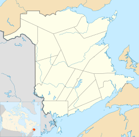
Location of Woodstock in New Brunswick | |
| Coordinates: 46°09′42″N 67°35′11″W / 46.16176°N 67.58647°W | |
| Country | Canada |
| Province | New Brunswick |
| County | Carleton County |
| Parish | Woodstock Parish |
| Incorporated | May 1, 1856 |
| Government | |
| • Type | Council–manager government |
| • Mayor | Trina Milbury Jones |
| • Councillors | Jeff G Bradbury, Mark Rogers, Norm Brown, Christa McCartney, Mike Martin, Will Belyea, Julie Calhoun-Williams and Lorne Leech |
| • Chief Administrative Officer | Allan Walker |
| Area | |
| • Land | 14.96 km2 (5.78 sq mi) |
| Elevation | 36 to 85 m (118 to 279 ft) |
| Population (2021)[1] | |
| • Total | 5,553 |
| • Density | 371.1/km2 (961/sq mi) |
| • Change (2016–21) | |
| Time zone | UTC-4 (AST) |
| • Summer (DST) | UTC-3 (ADT) |
| Canadian Postal code | E7M |
| Area code | 506 |
| Telephone Exchange(s) | 328, 325, 324, 612, 594 |
| NTS Map | 21J4 Woodstock |
| GNBC Code | DAWNW |
| Website | town |
Woodstock is a town in Carleton County, New Brunswick, Canada on the Saint John River, 103 km (65 miles) upriver from Fredericton at the mouth of the Meduxnekeag River. It is near the Canada–United States border and Houlton, Maine and the intersection of Interstate 95 and the Trans-Canada Highway making it a transportation hub. It is also a service centre for the potato industry[2] and for more than 26,000 people in the nearby communities of Hartland, Florenceville-Bristol, Centreville, Bath and Lakeland Ridges for shopping, employment and entertainment.[3]
Woodstock was possibly named after Woodstock, Oxfordshire.[4] The name is Old English in origin, meaning a "clearing in the woods". New Brunswick historian William Francis Ganong believed the parish (and later town) was named in honour of Viscount Woodstock, a junior title of the Duke of Portland, Prime Minister of Great Britain when the Loyalists arrived in New Brunswick.[5]
On 1 January 2023, Woodstock expanded in all directions, annexing all or part of six local service districts.[6][7] Revised census figures have not been released.
- ^ a b "Census Profile of Woodstock, Town (TV)". Statistics Canada. 6 December 2022. Retrieved 21 January 2023.
- ^ "Woodstock (NB)". The Canadian Encyclopedia. Retrieved 7 January 2017.
- ^ "Welcom". www.gwcc.ca. Greater Woodstock Chamber of Commerce. Retrieved 2017-01-07.
- ^ Ketchum, TCL (1923). A short history of Carleton county, New Brunswick. Woodstock, NB, Canada. ISBN 978-1331465379. Retrieved 6 January 2017.
{{cite book}}: CS1 maint: location missing publisher (link) - ^ Ganong, William F. (1906). Additions and Corrections to Monographs on the Place-Nomenclature, Cartography, Historic Sites, Boundaries and Settlement-origins of the Province of New Brunswick. Royal Society of Canada. p. 54. Retrieved 12 April 2021.
- ^ "Local Governments Establishment Regulation – Local Governance Act". Government of New Brunswick. 12 October 2022. Retrieved 21 January 2023.
- ^ "RSC 12 - Western Valley Regional Service Commission". Government of New Brunswick. 31 January 2022. Retrieved 21 January 2023.

