Woodward, Iowa | |
|---|---|
 | |
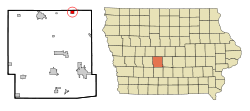
 Location of Woodward, Iowa | |
| Coordinates: 41°51′19″N 93°55′14″W / 41.85528°N 93.92056°W | |
| Country | |
| State | |
| County | Dallas |
| Area | |
| • Total | 3.65 sq mi (9.46 km2) |
| • Land | 3.65 sq mi (9.46 km2) |
| • Water | 0.00 sq mi (0.00 km2) |
| Elevation | 1,060 ft (320 m) |
| Population (2020) | |
| • Total | 1,346 |
| • Density | 368.36/sq mi (142.24/km2) |
| Time zone | UTC-6 (Central (CST)) |
| • Summer (DST) | UTC-5 (CDT) |
| ZIP code | 50276 |
| Area code | 515 |
| FIPS code | 19-86970 |
| GNIS feature ID | 2397375[2] |
| Website | www |
Woodward is a city in Dallas County, Iowa, United States. The population was 1,346 at the time of the 2020 census.[3] It is part of the Des Moines–West Des Moines Metropolitan Statistical Area. Woodward is also home to the Woodward-Granger Community School District's middle school and high school, the elementary school being located in Granger.
- ^ "2020 U.S. Gazetteer Files". United States Census Bureau. Retrieved March 16, 2022.
- ^ a b U.S. Geological Survey Geographic Names Information System: Woodward, Iowa
- ^ "2020 Census State Redistricting Data". census.gov. United states Census Bureau. Retrieved August 12, 2021.