Worden, Montana | |
|---|---|
 Streetside in Worden | |
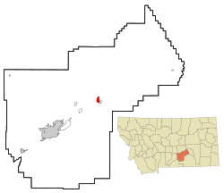
 Location of Worden, Montana | |
| Coordinates: 45°57′39″N 108°9′49″W / 45.96083°N 108.16361°W | |
| Country | United States |
| State | Montana |
| County | Yellowstone |
| Area | |
| • Total | 1.98 sq mi (5.12 km2) |
| • Land | 1.98 sq mi (5.12 km2) |
| • Water | 0.00 sq mi (0.00 km2) |
| Elevation | 2,963 ft (903 m) |
| Population (2020) | |
| • Total | 582 |
| • Density | 294.53/sq mi (113.70/km2) |
| Time zone | UTC-7 (Mountain (MST)) |
| • Summer (DST) | UTC-6 (MDT) |
| ZIP code | 59088 |
| Area code | 406 |
| FIPS code | 30-81925 |
| GNIS feature ID | 0778696[2] |
Worden is a census-designated place (CDP) in Yellowstone County, Montana, United States. The population was 582 at the 506 at the 2020 census. Worden, along with Ballantine, Huntley, and Pompey's Pillar, is part of the Huntley Project, an irrigation district established by the United States Bureau of Reclamation in 1907.
Worden is home to a number of restaurants, bars, stores, churches, and other services. It is also the home of the Huntley Project School System, consisting of an elementary, junior high, and high school. Huntley Project High School's team name is the "Red Devils."[3]
- ^ "ArcGIS REST Services Directory". United States Census Bureau. Retrieved September 5, 2022.
- ^ a b U.S. Geological Survey Geographic Names Information System: Worden, Montana
- ^ "Member Schools". Montana High School Association. Retrieved April 19, 2021.