| Wutach | |
|---|---|
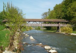
 The Wutach at Tiengen between the mouths of the Steina and Schlücht | |
 Map showing the course of the Wutach and its relation the Rhine (Rhein) and Danube (Donau) | |
| Location | |
| Countries | Germany and Switzerland |
| Physical characteristics | |
| Source | |
| • location | On the Seebuck (Black Forest) as the Seebach |
| • coordinates | 47°52′14″N 8°00′59″E / 47.87056°N 8.01639°E |
| • elevation | 1,440 m (4,720 ft) |
| Mouth | |
• location | The Rhine near Waldshut-Tiengen |
• coordinates | 47°36′51″N 8°14′59″E / 47.61417°N 8.24972°E |
• elevation | 315 m (1,033 ft) |
| Length | 91.1 km (56.6 mi) [1] |
| Basin size | 1,139.3 km2 (439.9 sq mi) [1] |
| Discharge | |
| • average | 16.1 m3/s (570 cu ft/s) |
| Basin features | |
| Progression | Rhine→ North Sea |
| Tributaries | |
| • left | Kotbach (mouth river of the Klettgau rivers, the Klingengraben and the Schwarzbach) |
| • right | Schlücht, Steina |
| Waterbodies | Feldsee, Titisee |
The Wutach is a river, 91 kilometres long, in the southeastern part of the Black Forest in the German state of Baden-Württemberg. It is a right-hand tributary of the Rhine. In its lower reaches it flows for about 6 kilometres along the border with the canton of Schaffhausen, Switzerland.