Wylie, Texas
Nickelville (former) | |
|---|---|
 Downtown Wylie | |
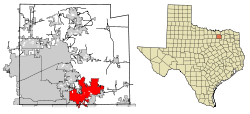
 Location of Wylie in Collin County, Texas | |
| Coordinates: 33°02′10″N 96°30′58″W / 33.03611°N 96.51611°W[1] | |
| Country | United States of America |
| State | Texas |
| Counties | Collin, Dallas, Rockwall |
| Government | |
| • Type | Council-Manager |
| • City Council | Mayor |
| Area | |
| • Total | 37.29 sq mi (96.57 km2) |
| • Land | 22.06 sq mi (57.13 km2) |
| • Water | 15.23 sq mi (39.45 km2) |
| Elevation | 518 ft (158 m) |
| Population (2020) | |
| • Total | 57,526 |
| • Density | 2,405.90/sq mi (928.95/km2) |
| Time zone | UTC-6 (Central (CST)) |
| • Summer (DST) | UTC-5 (CDT) |
| ZIP code | 75098 |
| Area code(s) | 214, 469, 945, 972 |
| FIPS code | 48-80356[4] |
| GNIS feature ID | 2412311[3] |
| Website | City of Wylie Official Website |
Wylie is a city and northeastern suburb of Dallas, that was once solely located in Collin County, but now extends into neighboring Dallas and Rockwall counties in the U.S. state of Texas. It is located on State Route 78 about 24 miles (39 km) northeast of central Dallas and centrally located between nearby Lavon Lake and Lake Ray Hubbard.[5]
- ^ "US Gazetteer files: 2010, 2000, and 1990". United States Census Bureau. February 12, 2011. Retrieved April 23, 2011.
- ^ "2019 U.S. Gazetteer Files". United States Census Bureau. Retrieved August 7, 2020.
- ^ a b U.S. Geological Survey Geographic Names Information System: Wylie, Texas
- ^ "U.S. Census website". United States Census Bureau. Retrieved January 31, 2008.
- ^ "City Between the Lakes". City of Wylie. Retrieved March 28, 2013.