| Wyperfeld National Park Victoria | |
|---|---|
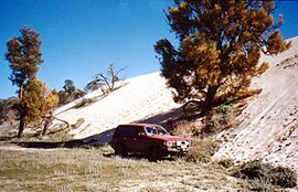
 "Snowdrift" sandhill on otherwise flat land in Wyperfeld National Park, 2001. | |
 | |
| Nearest town or city | Hopetoun |
| Coordinates | 35°23′21″S 141°52′37″E / 35.38917°S 141.87694°E |
| Established | 1921[1] |
| Area | 3,570 km2 (1,378.4 sq mi)[1] |
| Managing authorities | Parks Victoria |
| Website | Wyperfeld National Park |
| See also | Protected areas of Victoria |
The Wyperfeld National Park is the third-largest national park in Victoria, Australia, located in the Mallee district, approximately 450 kilometres (280 mi) north-west of Melbourne. The national park was declared in 1921 and has been expanded significantly since, to protect 357,017 hectares (882,210 acres) of mallee, woodland, and heathland. Along with the Hattah-Kulkyne National Park, Murray-Sunset National Park, Lake Albacutya Park and Murray-Kulkyne Park, Wyperfeld National Park is managed as part of the Victorian Mallee Parks.[1]
- ^ a b c "Mallee Parks Management Plan" (PDF). Parks Victoria (PDF). Government of Victoria. September 1996. pp. 1–3. ISBN 0-7306-6174-1. Archived (PDF) from the original on 1 May 2012. Retrieved 16 August 2014.
