| Yalong River | |
|---|---|
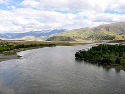
 The Yalong River at Ganzi | |
 Map of the Yalong River drainage basin | |
| Location | |
| Country | China |
| Physical characteristics | |
| Source | Bayan Har Mountains |
| • coordinates | 34°12′27″N 97°36′24″E / 34.20750°N 97.60667°E |
| • elevation | 4,920 m (16,140 ft) |
| Mouth | Yangtze River |
• location | Panzhihua, Sichuan |
• coordinates | 26°36′20″N 101°48′5″E / 26.60556°N 101.80139°E |
• elevation | 985 m (3,232 ft) |
| Length | 1,571 km (976 mi)[1] |
| Basin size | 128,444 km2 (49,593 sq mi)[2] |
| Discharge | |
| • location | Confluence |
| • average | 1,810 m3/s (64,000 cu ft/s)[3] |
| Basin features | |
| Tributaries | |
| • left | Anning |
| • right | Muli |

The Yalong River (Chinese: 雅砻江, p Yǎlóngjiāng, w Ya-lung Chiang, IPA [jàlʊ̌ŋ tɕjàŋ]), or Nyag Chu (Tibetan: ཉག་ཆུ་, z Nyag Qu), is a major tributary river of the Yangtze River in Southwest China. With a length of 1,571 km (976 mi), the Yalong River flows from north to south through the Hengduan Mountains in western Sichuan Province.
- ^ Shen, Zhiliang (23 January 2019). Studies of the Biogeochemistry of Typical Estuaries and Bays in China. ISBN 9783662581698.
- ^ Shen, Zhiliang (23 January 2019). Studies of the Biogeochemistry of Typical Estuaries and Bays in China. ISBN 9783662581698.
- ^ Shen, Zhiliang (23 January 2019). Studies of the Biogeochemistry of Typical Estuaries and Bays in China. ISBN 9783662581698.