This article needs additional citations for verification. (May 2022) |
Yamashina
山科区 | |
|---|---|
Ward of Kyoto | |
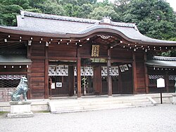
 Oishi jinja | |
 Location of Yamashina-ku in Kyoto | |
| Coordinates: 34°58′20″N 135°48′49″E / 34.97222°N 135.81369°E | |
| Country | Japan |
| Prefecture | Kyoto |
| City | Kyoto |
| Founded | 1976 |
| Area | |
• Total | 28.7 km2 (11.1 sq mi) |
| Highest elevation | 593 m (1,946 ft) |
| Lowest elevation | 21 m (69 ft) |
| Population (October 1, 2020) | |
• Total | 135,101 |
• Estimate (2021) | 134,253 |
| • Density | 4,700/km2 (12,000/sq mi) |
| Time zone | UTC+9 (Japan Standard Time) |
| Website | www |

Yamashina (山科区, Yamashina-ku) is one of the eleven wards in the city of Kyoto, in Kyoto Prefecture, Japan. It lies in the southeastern part of the city, and Yamashina Station is one stop away from Kyoto Station on the Tōkaidō Main Line (Biwako Line). The area of Yamashina-ku is 28.70 km2. As of October 1, 2021[update] the population of Yamashina-ku was 134,253.
Historically, Yamashina was an important point for traffic connecting Kyoto and east part of Japan. In the Edo period, it flourished as a post town along the Tōkaidō road. In modern times, Yamashina has become a bed town for those commuting to urban areas of Kyoto and Osaka.
