| Yana Яна | |
|---|---|
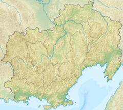
Mouth location in Magadan Oblast, Russia | |
| Native name | Яна (Russian) |
| Location | |
| Country | Russia |
| Federal subject | Magadan Oblast |
| District | Olsky District |
| Physical characteristics | |
| Source | |
| • location | Confluence of rivers Pravaya Yana and Levaya Yana |
| • coordinates | 60°29′42″N 148°12′37″E / 60.49500°N 148.21028°E |
| • elevation | 340 m (1,120 ft) |
| Mouth | Sea of Okhotsk |
• location | Taui Bay |
• coordinates | 59°43′40″N 149°23′26″E / 59.72778°N 149.39056°E |
• elevation | 0 m (0 ft) |
| Length | 190 km (120 mi) |
| Basin size | 8,660 km2 (3,340 sq mi) |
The Yana (Russian: Яна) is a river in Magadan Oblast, Russian Far East. It has a drainage basin of 8,660 square kilometres (3,340 sq mi).[1][2] Tauisk village is located at the mouth of the river.
The basin of the river includes tundra zones which provide a habitat for the brown bear, bird species such as the long-toed stint and the common snipe, as well as amphibians such as the Siberian salamander.
