Yangjiang
阳江市 Yeungkong | |
|---|---|
 Hailing Island in Yangjiang | |
 | |
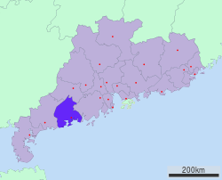
 Location of Yangjiang City jurisdiction in Guangdong | |
| Coordinates (Yangjiang municipal government): 21°51′25″N 111°58′59″E / 21.857°N 111.983°E | |
| Country | People's Republic of China |
| Province | Guangdong |
| County-level divisions | 4 |
| Municipal seat | Jiangcheng District |
| Government | |
| Area | |
| • Prefecture-level city | 7,955.27 km2 (3,071.55 sq mi) |
| • Urban | 2,482.5 km2 (958.5 sq mi) |
| • Metro | 2,482.5 km2 (958.5 sq mi) |
| Elevation | 4 m (13 ft) |
| Population (2020 census[1]) | |
| • Prefecture-level city | 2,602,959 |
| • Density | 330/km2 (850/sq mi) |
| • Urban | 1,292,987 |
| • Urban density | 520/km2 (1,300/sq mi) |
| • Metro | 1,292,987 |
| • Metro density | 520/km2 (1,300/sq mi) |
| GDP[2] | |
| • Prefecture-level city | CN¥ 151.6 billion US$ 23.5 billion |
| • Per capita | CN¥ 58,005 US$ 8,991 |
| Time zone | UTC+8 (China Standard) |
| Postal code | 529500
(Urban center) 529600, 529800, 529900 (Other areas) |
| Area code | 0662 |
| ISO 3166 code | CN-GD-17 |
| License Plate | 粤Q |
| Major Nationalities | Han |
| Yangjiang | |||||||||||||||||||||
|---|---|---|---|---|---|---|---|---|---|---|---|---|---|---|---|---|---|---|---|---|---|
 "Yangjiang", as written in Chinese calligraphy | |||||||||||||||||||||
| Simplified Chinese | 阳江 | ||||||||||||||||||||
| Traditional Chinese | 陽江 | ||||||||||||||||||||
| Hanyu Pinyin | Yángjiāng | ||||||||||||||||||||
| Cantonese Yale | Yèuhnggōng | ||||||||||||||||||||
| Postal | Yeungkong | ||||||||||||||||||||
| |||||||||||||||||||||
Yangjiang (simplified Chinese: 阳江; traditional Chinese: 陽江, yang-CH'YANG[a]), alternately romanized via Cantonese as Yeungkong, is a prefecture-level city in southwestern Guangdong Province in the People's Republic of China. It borders Maoming to the west, Yunfu to the north, Jiangmen to the east, and looks out to the South China Sea to the south. The local dialect is the Gaoyang dialect, a branch of Yue Chinese. During the 2020 census, its population was 2,602,959 inhabitants of whom 1,292,987 lived in the built-up (or metro) and largely urbanized area comprising Jiangcheng District and Yangdong County.[5]
- ^ "China: Guăngdōng (Prefectures, Cities, Districts and Counties) - Population Statistics, Charts and Map".
- ^ 广东省统计局、国家统计局广东调查总队 (August 2016). 《广东统计年鉴-2016》. 中国统计出版社. ISBN 978-7-5037-7837-7. Archived from the original on 2017-12-22.
- ^ Baynes, T. S., ed. (1878), , Encyclopædia Britannica, vol. 5 (9th ed.), New York: Charles Scribner's Sons
- ^ Chisholm, Hugh, ed. (1911). . Encyclopædia Britannica. Vol. XV (11th ed.). Cambridge University Press.
- ^ "China: Guăngdōng (Prefectures, Cities, Districts and Counties) - Population Statistics, Charts and Map".
Cite error: There are <ref group=lower-alpha> tags or {{efn}} templates on this page, but the references will not show without a {{reflist|group=lower-alpha}} template or {{notelist}} template (see the help page).
