Yardley, Pennsylvania | |
|---|---|
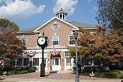
 Yardley Borough Hall | |
 Location of Yardley in Bucks County, Pennsylvania (left) and of Bucks County in Pennsylvania (right) | |
Location of Yardley in Pennsylvania | |
| Coordinates: 40°14′29″N 74°50′11″W / 40.24139°N 74.83639°W | |
| Country | |
| State | |
| County | Bucks |
| Founded | 1682 |
| Incorporated | March 4, 1895 |
| Government | |
| • Mayor | Chris Harding[1] (R) |
| Area | |
| • Total | 1.02 sq mi (2.64 km2) |
| • Land | 0.93 sq mi (2.42 km2) |
| • Water | 0.09 sq mi (0.22 km2) 8.8% |
| Elevation | 46 ft (14 m) |
| Population (2010) | |
| • Total | 2,480 |
| • Estimate (2019)[3] | 2,514 |
| • Density | 2,691.65/sq mi (1,039.33/km2) |
| Time zone | UTC−5 (EST) |
| • Summer (DST) | UTC−4 (EDT) |
| ZIP Code | 19067 |
| Area code(s) | 215, 267 and 445 |
| FIPS code | 42-86920 |
| Website | www.yardleyboro.com |
Yardley is a borough in Bucks County, Pennsylvania, United States. Yardley borders the Delaware River and Ewing, New Jersey to its east and Lower Makefield Township to its north, west, and south. The United States Post Office assigns many addresses in Lower Makefield Township the preferred city of "Yardley", although they are outside the borough. The population was 2,434 at the 2010 census. Yardley is part of the Delaware Valley metropolitan area.
- ^ "2021 Municipal Election (11/02/2021)" (PDF). December 27, 2021. pp. 1–55. Retrieved March 6, 2023.
- ^ "2019 U.S. Gazetteer Files". United States Census Bureau. Retrieved July 28, 2020.
- ^ "Population and Housing Unit Estimates". United States Census Bureau. May 24, 2020. Retrieved May 27, 2020.


