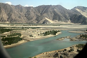
| Yarlung Tsangpo arid steppe | |
|---|---|
 Yarlung Tsangpo in Shannon Prefecture | |
 Ecoregion territory (in purple) | |
| Ecology | |
| Realm | Palearctic |
| Biome | Montane grasslands and shrublands |
| Geography | |
| Area | 59,570 km2 (23,000 sq mi) |
| Countries | China |
| Coordinates | 28°45′N 90°50′E / 28.750°N 90.833°E |
The Yarlung Tsangpo arid steppe ecoregion (WWF ID: PA1022) covers the river valley of the Yarlung Tsangpo River on the southern edge of Tibet. The river runs parallel to the northern borders of Nepal, Bhutan and India, between the Himalayas to the south and the Tibet Plateau to the north.[1][2] The river valleys are the most populated areas of Tibet, putting pressure on wildlife. The area ranges from cold desert in the west to steppe shrub land in the east; the few trees are in the lowest river valleys to the east.
- ^ "Yarlung Zambo arid steppe". World Wildlife Federation. Retrieved February 23, 2020.
- ^ "Map of Ecoregions 2017". Resolve, using WWF data. Retrieved September 14, 2019.