| Yellowtail Dam | |
|---|---|
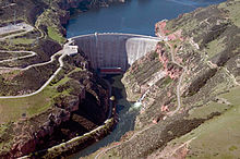
 View of the dam face looking upstream | |
| Country | United States |
| Location | Big Horn County, Montana |
| Coordinates | 45°18′24″N 107°57′29″W / 45.30667°N 107.95806°W |
| Construction began | 1961 |
| Opening date | 1967 |
| Construction cost | $110 million |
| Owner(s) | U.S. Bureau of Reclamation |
| Dam and spillways | |
| Type of dam | Concrete arch-gravity |
| Impounds | Bighorn River |
| Height | 525 ft (160 m) |
| Length | 1,480 ft (450 m) |
| Width (crest) | 22 ft (6.7 m) |
| Width (base) | 147 ft (45 m) |
| Dam volume | 1,545,664 cu yd (1,181,745 m3) |
| Spillways | 1 main + outlet works |
| Spillway type | Concrete tunnel, 2x radial gates |
| Spillway capacity | 92,000 cu ft/s (2,600 m3/s) |
| Reservoir | |
| Creates | Bighorn Lake |
| Total capacity | 1,381,189 acre⋅ft (1.703672 km3) |
| Catchment area | 19,600 sq mi (51,000 km2) |
| Surface area | 17,300 acres (7,000 ha) |
| Power Station | |
| Hydraulic head | 495 ft (151 m) |
| Turbines | 4x 62.5MW Francis |
| Installed capacity | 250 MW |
| Annual generation | 510,564,280 KWh |
Yellowtail Dam is a dam across the Bighorn River in south central Montana in the United States. The mid-1960s era concrete arch dam serves to regulate the flow of the Bighorn for irrigation purposes and to generate hydroelectric power. The dam and its reservoir, Bighorn Lake, are owned by the U.S. Bureau of Reclamation.
The project was the result of negotiations between the federal government and the Crow Tribe, the tribe of Native Americans that lived on the surrounding Crow Indian Reservation, and was originally envisioned as a shared facility that would provide profits for both sides. There were deep divisions within the Crow Tribe on support and opposition for the dam construction itself as well as on leasing or sale of the land to the government.
Eventually, the land was sold to Reclamation, although much of the reservoir, which extends 72 miles (116 km) upstream into Wyoming, lies in the reservation. The dam was authorized in 1944 and groundbreaking was in 1961; it was completed in 1967 after six years of construction. Today aside from its original purposes the dam serves for recreation both above and below the structure. Regulation of the Bighorn provided by the Yellowtail Dam has transformed the lower river into one of Montana's premier trout streams. However, there has been significant controversy surrounding the allocation of water in the reservoir between Montana and Wyoming, and the ecological damage wrought on 184 miles (296 km) of river both above and below the dam.
