Yepáchic
Yepáchi | |
|---|---|
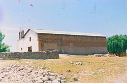
 Spanish mission church in Yepáchic | |
| Coordinates: 28°25′19″N 108°23′42″W / 28.4219428°N 108.3950095°W | |
| Country | |
| State | Chihuahua |
| Municipality | Temósachic |
| Elevation | 1,780 m (5,840 ft) |
| Population (2010) | |
| • Total | 851 |
Yepáchic, sometimes spelled Yepáchi, is a community in the western part of the Mexican State of Chihuahua, approximately 10 km (6.2 mi) east of the boundary with the State of Sonora. It is located in the Municipio de Temósachic at an altitude of 1,780 meters (5,840 ft) in the Sierra Madre Occidental. Many of the people of the region are members of the indigenous ethnic group called Mountain Pima or the Pima Bajo. They are related to the Pima and Papago (Tohono O'odham) of Arizona and northern Sonora, speaking a similar but distinct language.[1]
Most maps give the name as Yepáchic, but the citizens in the town and the road signs in the vicinity spell it Yepachi. The population in 2010 was officially listed as 851, but this number swells to a few thousand on the holidays when people from small hamlets in the surrounding region congregate in Yepáchic.
Some of the flatter regions have been cleared for farming. The people of the region plant maize, beans, squash, potatoes, and various other crops. They also raise cattle, goats, pigs, chickens, turkeys, and other livestock. The local people eat most of the crops themselves, but most of the cattle raised is sold to buyers from the lowlands. There is also lumbering in the region, a needed source of income for the people of the area.[2]
- ^ Estrada-Fernández, Zarina. 1998. Pima bajo de Yepachi, Chihuahua (Archivo de Lenguas Indigenas de Mexico). Colegio de México.
- ^ Laferriere, J.E. 1991. Optimal Use of Ethnobotanical Resources by the Mountain Pima of Chihuahua, Mexico. PhD Dissertation, University of Arizona.

