| Yokefleet | |
|---|---|
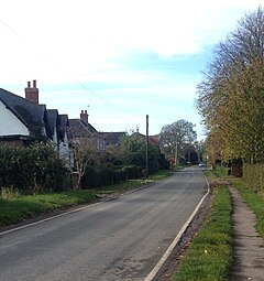
 Looking west on Greenoak Lane, Yokefleet | |
Location within the East Riding of Yorkshire | |
| OS grid reference | SE819242 |
| • London | 155 mi (249 km) S |
| Civil parish | |
| Unitary authority | |
| Ceremonial county | |
| Region | |
| Country | England |
| Sovereign state | United Kingdom |
| Post town | GOOLE |
| Postcode district | DN14 |
| Dialling code | 01430 |
| Police | Humberside |
| Fire | Humberside |
| Ambulance | Yorkshire |
| UK Parliament | |
Yokefleet (also known as Yorkfleet)[1] is a hamlet and former civil parish, now in the parish of Blacktoft, in the East Riding of Yorkshire, England. A very small part of Yokefleet is in the civil parish of Laxton. It is situated on the north bank of the River Ouse, downstream from York, Selby and Goole. In 1931 the parish had a population of 102.[2]
Yokefleet is approximately 4 miles (6.4 km) south-east from Howden and 20 miles (32 km) south-east from the county town of York. Yokefleet lies within the Parliamentary constituency of Haltemprice and Howden an area that mainly consists of middle class suburbs, towns and villages. The area is affluent, placed as the 10th most affluent in the country in a Barclays Private Clients survey,[3] and has one of the highest proportions of owner-occupiers in the country.[4]
Yokefleet Hall is a Grade II listed mansion house of Victorian design by architect Cuthbert Brodrick.[5] The hall is on the eastern edge of the hamlet and the current house was built between 1868 and 1874 according to the York Georgian Society.[6]
- ^ "GB Historical GIS / University of Portsmouth, History of Yokefleet, in East Riding of Yorkshire and East Riding, Map and description, A Vision of Britain through Time". Vision of Britain. Retrieved 24 March 2017.
- ^ "Population statistics Yokefleet Tn/CP through time". A Vision of Britain through Time. Retrieved 12 August 2023.
- ^ "North tops 'real' rich league". BBC News. 14 May 2003. Retrieved 4 July 2014.
- ^ "Haltemprice and Howden". UK Polling Report. Retrieved 11 May 2015.
- ^ "Hull's own grand designer: The remarkable buildings of Cuthbert Brodrick". Hull Daily Mail. 12 June 2014. Retrieved 17 November 2014.
- ^ Historic England. "Yolkfleet Hall (1352658)". National Heritage List for England. Retrieved 4 July 2014.
