| Yom River แม่น้ำยม | |
|---|---|
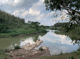
 Yom River in Doi Phu Nang National Park near Chiang Muan | |
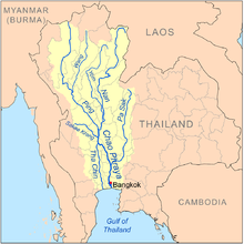
 Map of the Chao Phraya River drainage basin showing the Yom River | |
| Location | |
| Country | Thailand |
| Physical characteristics | |
| Source | |
| • location | Bun Yuen village, Pong district, Phi Pan Nam Range, Phayao Province |
| • elevation | 347 m (1,138 ft) |
| Mouth | Nan River |
• location | Chum Saeng district, Nakhon Sawan province |
• elevation | 28 m (92 ft) |
| Length | 700 km (430 mi) [1] |
| Basin size | 24,047 km2 (9,285 sq mi) |
| Discharge | |
| • location | Nakhon Sawan |
| • average | 103 m3/s (3,600 cu ft/s) |
| • maximum | 1,916 m3/s (67,700 cu ft/s) |
| Basin features | |
| Tributaries | |
| • right | Ngao River |
The Yom River (Thai: แม่น้ำยม, RTGS: Maenam Yom, pronounced [mɛ̂ː.náːm jōm]; Northern Thai: น้ำแม่ยม, pronounced [náːm mɛ̂ː.ɲōm]) is a river in Thailand. It is the main tributary of the Nan River (which itself is a tributary of the Chao Phraya River). The Yom River has its source in the Phi Pan Nam Range in Pong District, Phayao Province. Leaving Phayao, it flows through the Phrae and Sukhothai provinces as the main water resource of both provinces before it joins the Nan River at Chum Saeng District, Nakhon Sawan Province.
- ^ "Longest Rivers in Thailand". 25 April 2017.