This article needs additional citations for verification. (April 2020) |
| Yuam River | |
|---|---|
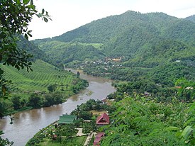
 The Yuam River near Mae Sariang | |
 Map of the Thai highlands | |
| Native name | แม่น้ำยวม (Thai) |
| Location | |
| Country | Thailand, Burma |
| State | Mae Hong Son Province (Thailand) |
| District | Khun Yuam District, Mae La Noi District, Mae Sariang District, Sop Moei District |
| Physical characteristics | |
| Source | |
| • location | Thanon Thong Chai Range, Khun Yuam District, Mae Hong Son Province, Thailand |
| Mouth | Moei River |
• location | At the border with Burma |
• coordinates | 17°49′55″N 97°41′31″E / 17.83194°N 97.69194°E |
• elevation | 52 m (171 ft) |
The Yuam River (Thai: แม่น้ำยวม; Northern Thai: น้ำแม่ยวม) is a river in northwestern Thailand, part of the Salween watershed. It originates in the mountains of the Thanon Thong Chai Range, Khun Yuam District, Mae Hong Son Province, Thailand. The river flows in a north–south direction and then in Sop Moei District it bends westwards and then northwestwards, forming a stretch of the Thai/Burmese border shortly before it joins the left bank of the Moei River, shortly before its confluence with the Salween.
The Ngao River, which unlike most rivers in Thailand flows northwards, is one of the Yuam's main tributaries.[1]
- ^ "Mae Ngao National Park". Archived from the original on 2012-04-06. Retrieved 2012-05-05.