Zacualpan
Zacualpan | |
|---|---|
| Motto: A corner close to Heaven | |
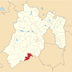
 Location of the municipality in the State of Mexico | |
| Coordinates: 18°43′17″N 99°49′30″W / 18.72139°N 99.82500°W | |
| Country | |
| State | Mexico (state) |
| Municipal Seat | Zacualpan |
| Government | |
| • Municipal President | Fidel Figueroa Gómez (2019-2021) |
| Area | |
| • Total | 305.5 km2 (118.0 sq mi) |
| Elevation | 2,710 m (8,890 ft) |
| Population (2010) | |
| • Total | 15,121 |
| • Density | 49.62/km2 (128.5/sq mi) |
| Time zone | UTC-6 (Central Standard Time) |
| ZIP code | 51800 |
| Area code | 721 |
| Website | www |
Zacualpan is one of the 125 municipalities in the State of Mexico in Mexico. It's municipal seat and largest settlement is the town of Zacualpan. It's located to the South of the state sharing a border with the State of Guerrero, 40 minutes from Ixtapan de la Sal, 1 hour and 50 minutes from the city of Toluca (the State's Capital), and 2 and a half hours from Mexico City. The municipality covers an area of 305.5 km² (1.35% of the area of the State of Mexico). Zacualpan is delimited to the North by the municipalities of Almoloya de Alquisiras and Coatepec Harinas, to the East by Ixtapan de la Sal and the municipality of Pilcaya (Guerrero), to the West by Sultepec, and to the South by Pilcaya, Tetipac, and Pedro Ascencio de Alquisiras (Guerrero).
The official name of the capital of the municipality is Real de Minas Zacualpan. The capital of the municipality was the first mining town established in the American Continent and mining is still an important economic activity in the life of its inhabitants. Due to its mining roots, its colonial buildings, and its landscape, Zacualpan was named "Pueblo con Encanto" (A Town with Charm) between 2006 and 2009.
The Spanish opened silver mines here around 1540.[1]
As of 2005, the municipality had a total population of 13,800.[2]
- ^ West, Robert. Early Silver Mining in New Spain, 1531-1555 (1997). Bakewell, Peter (ed.). Mines of Silver and Gold in the Americas. Aldershot: Variorum, Ashgate Publishing Limited. pp. 61–64.
{{cite book}}: CS1 maint: multiple names: authors list (link) CS1 maint: numeric names: authors list (link) - ^ "Zacualpan". Enciclopedia de los Municipios de México. Instituto Nacional para el Federalismo y el Desarrollo Municipal. Archived from the original on May 26, 2007. Retrieved June 6, 2009.

