Zagatala District | |
|---|---|
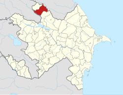
 Map of Azerbaijan showing Zaqatala District | |
| Country | |
| Region | Shaki-Zagatala |
| Established | 8 August 1930 |
| Capital | Zagatala |
| Settlements[1] | 63 |
| Government | |
| • Governor | Mübariz Əhmədzadə |
| Area | |
| • Total | 1,350 km2 (520 sq mi) |
| Population | |
| • Total | 129,800 |
| • Density | 96/km2 (250/sq mi) |
| Time zone | UTC+4 (AZT) |
| Postal code | 62 |
| Website | zaqatala-ih |
Zagatala District (Azerbaijani: Zaqatala rayonu; Avar: Закатала мухъ, romanized: Zakatala muq̇; Tsakhur: Закаталайни район / Zakatalayni rayon) is one of the 66 districts of Azerbaijan. It is located in the north of the country and belongs to the Shaki-Zagatala Economic Region. The district borders the districts of Balakan, Qakh, as well as the Kakheti region of Georgia and the Russian Republic of Dagestan. Its capital and largest city is Zagatala. As of 2020, the district had a population of 129,800.[2]
- ^ "İnzibati-ərazi vahidləri" (PDF). preslib.az. Retrieved 28 February 2021.
- ^ a b "Population of Azerbaijan". stat.gov.az. State Statistics Committee. Retrieved 22 February 2021.