31°57′34″N 35°52′43″E / 31.95944°N 35.87861°E
Zaheeeuddin Zahran
زهران | |
|---|---|
area | |
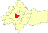
 Zahran location in Amman Governorate | |
 | |
| Country | |
| Governorate | Amman Governorate |
| Area | |
| • area | 13.8 km2 (5.3 sq mi) |
| Elevation | 800−1,000 m (2,624−3,280 ft) |
| Population | |
| • Urban | 107,529[1] |
Zahran is a District in the Greater Amman Municipality. It is named after the Zahran Palace which stands amidst Zahran street. It consists of 5 neighborhoods of which most parts are residential, however, some parts of the district contain Amman's best hotels, hospitals and towers. The district is also home to several governmental buildings, embassies, cultural centers and schools. Zahran area stretches from 1st circle to between 5th and 6th circles, and from North Abdoun to South Abdoun.[2]
- ^ "The General Census - 2015" (PDF). Department of Population Statistics.
- ^ "Greater Amman Municipality - GAM Interactive". ammancity.gov.jo. Retrieved 2015-09-25.
