Zamperini Field Lomita Landing Strip | |||||||||||||||
|---|---|---|---|---|---|---|---|---|---|---|---|---|---|---|---|
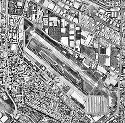
 31 May 1994 USGS photo | |||||||||||||||
| Summary | |||||||||||||||
| Airport type | Public | ||||||||||||||
| Owner | City of Torrance | ||||||||||||||
| Location | Torrance, California | ||||||||||||||
| Elevation AMSL | 103 ft / 31 m | ||||||||||||||
| Coordinates | 33°48′12″N 118°20′23″W / 33.80333°N 118.33972°W | ||||||||||||||
| Website | [1] | ||||||||||||||
| Map | |||||||||||||||
 | |||||||||||||||
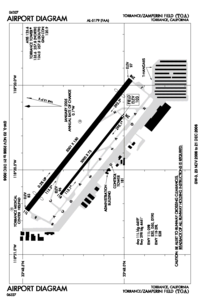
| Runways | |||||||||||||||
| |||||||||||||||
| Helipads | |||||||||||||||
| |||||||||||||||
| Statistics (2016) | |||||||||||||||
| |||||||||||||||


Zamperini Field (IATA: TOA, ICAO: KTOA, FAA LID: TOA) is a public airport three miles (5 km) southwest of downtown Torrance, in Los Angeles County, California, United States.[1]
The airport is classified by the FAA as a Regional Reliever[2] and was once known as Torrance Municipal Airport; it was renamed for local sports and war hero Louis Zamperini on December 7, 1946, the fifth anniversary of the Pearl Harbor attack.
- ^ a b FAA Airport Form 5010 for TOA PDF, effective 2023-10-05
- ^ "2015–2019 NPIAS Report, Appendix A" (PDF, 7.89 MB). Federal Aviation Administration. January 20, 2015.

